Seminoe Dunes Ponds
What Can We Learn from the Ponds in the Seminoe Dunes?
The Seminoe Dunes are south of the Ferris Mountains and east of the Seminoe Mountains. This gives the appearance that the Seminoe Dunes are at the eastern edge of the Great Divide Basin. However, they are drained by Sand Creek, which flows between the Ferris and Seminoe mountains into the North Platte River. The dunes are thus on the eastern slope of the continental divide. The more active part of the dune field, as indicated by bare sand on USGS imagery of The National Map, is about 10 km (6 miles) across at its southwestern edge and it extends about 15 km (9 miles) to the northeast. It has a triangular or funnel-like shape tapering down wind. More stable, vegetated dunes extend over a wider area and may also host ponds.
Ponds are scattered across the inter-dune areas of the Seminoe dune field. They are largely fed by melting snow, like those in the Killpecker Dunes. Summer thunderstorms would extend pond lifetimes. Both the 1:100,000-scale BLM map and the 7.5-minute topographic quadrangle show several ponds in the Seminoe Dunes south or east of Ferris. Some are barely 30 m (100′) across and some are a few hundred meters (thousands’) long. USGS imagery (of unknown vintage) displayed by The National Map viewer shows that some of the mapped ponds are no longer present and new ones have appeared since the 1949 aerial photographs for the 7.5-minute topographic quadrangle.
Elevations in the Seminoe Dunes range from about 2,000 m to about 2,200 m (6,560-7,220′).
Mean Annual Precipitation according to the Wyoming Climate Atlas by the Water Resources Data System and State Climate Office at http://www.wrds.uwyo.edu/sco/climateatlas/precipitation.html, Parameter-Elevation Regressions on Independent Slopes Model, PRISM, with 1971-2000 data at very widely spaced weather stations (I have eyeballed the values from a very small scale map with 11 precipitation bins marked with indistinct colors and further obscured by a shaded relief base map):
11″-15″ (28-38 cm)
Sagebrush is common in the area and there are grasses and rushes around the ponds.
The Seminoe Dunes are in an area with an irregular pattern of private, public, and state land. Approximately equal abundances of private and public lands make the Seminoe Dunes less welcoming for recreation than the Killpecker Dunes. There are state-owned sections south of Ferris and at Sand Springs and there are smaller state parcels scattered around as well. Like in the Killpecker Dunes, there has been oil and gas development among the dunes. This is not all bad as I think it means roads across private lands to wells, pipelines, and oil tanks have public right-of-ways.
Seminoe Dunes Ponds (Rawlins BLM Office, private)
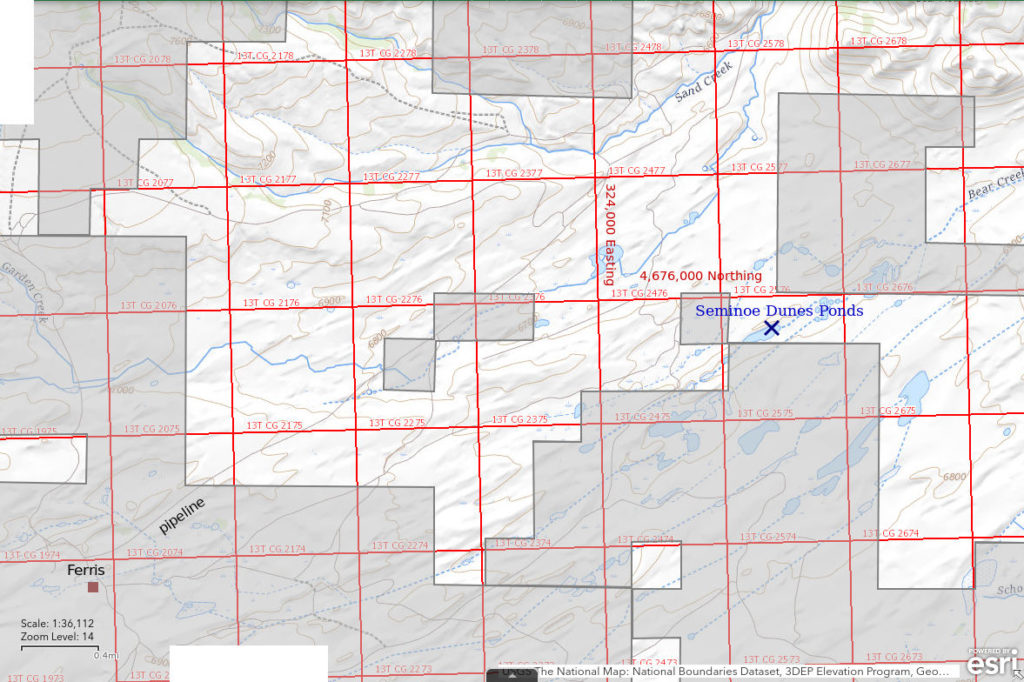
___This map is a screenshot of The National Map (Go to The National Map). The U.S. Geological Survey generally does not copyright or charge for its data or reports (unless printed). A pond location is indicated by an “X”, which corresponds to the coordinates given in the data spreadsheet. Labels in quotations are from 7.5-minute topographic quadrangles.
___Red lines are the U. S. National Grid with a spacing of 1,000 m and intersection labels consisting of the UTM zone (e.g., 11S, 12T), a 2-letter 100-km square designation (e.g., LC, XN), and a 4-digit number. The first 2 digits of the number represent the 1,000-meter Easting and the second 2 digits the 1,000-meter Northing, as seen in the example Easting and Northing. Unlike latitude and longitude, the National Grid is rectilinear on a flat map, the units of abscissa and ordinate have equal lengths, and the units (meters) are measurable on the ground with a tape or by pacing.
___Gray shading represents private land as traced from the PAD-US 2.0 – Federal Fee Managers layer of The National Map. Other lands are public or are owned by the State of Wyoming.

Seminoe Dunes Ponds are scattered through the Seminoe Dunes field. Almost 20 are shown on the Bairoil 30-minute x 60-minute topographic map even at the scale of 1:100,000. The pond location on the map was chosen for illustrative purposes because the pond is present on both The National Map and USGS imagery. I may or may not have visited this specific pond. The map for Seminoe Dunes Ponds does not show the entire dune field. There are more ponds and considerably more sand to the south and west.
The best route is to turn east off US 287 4-4.5 miles south of Lamont. This maintained road leads to the site of Ferris. About 1/4 mile west of the Ferris oil tanks, the maintained road turns sharply north and then, after 2 more miles, sharply east. It continues down Sand Creek Canyon to Sand Creek Ranch, also known as Buzzard Ranch. This road eventually connects to Wyoming 220 about 4 miles northeast of Independence Rock. There are other roads that lead northeast of Ferris and get closer to ponds shown on the map. Any of the roads may be blocked from time to time by encroaching sand or by snow in the winter.
Elevation: 2,035 m (6,677′)
July 5, 1989
I visited several ponds close to roads but didn’t take notes of individual ponds. Below is a summary of my observations.
- Sizes and depths not estimated for various ponds.
- Water varies from clear to stinky brown.
- No fairy shrimp.
- Common amphipods and cladocerans, avocets.

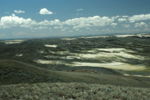
Looking upwind across the Seminoe Dunes from Junk Hill, at the north end of the Seminoe Mountains. Several ponds with water are in this view but they are hard to distinguish from the dark surrounding vegetation and cloud shadows. This photograph was taken in June 3 years after I visited the ponds.
What Can We Learn from the Ponds in the Seminoe Dunes?
I did not find fairy shrimp in the several ponds that I looked at.
The presence of cladocerans at some ponds suggests the water chemistry is not inimical to colonization by fairy shrimp.
Aerial imagery shows that ponds change shape, appear, and disappear over a period of a few decades. Maybe such physical changes prevent the establishment of persistent fairy shrimp populations.