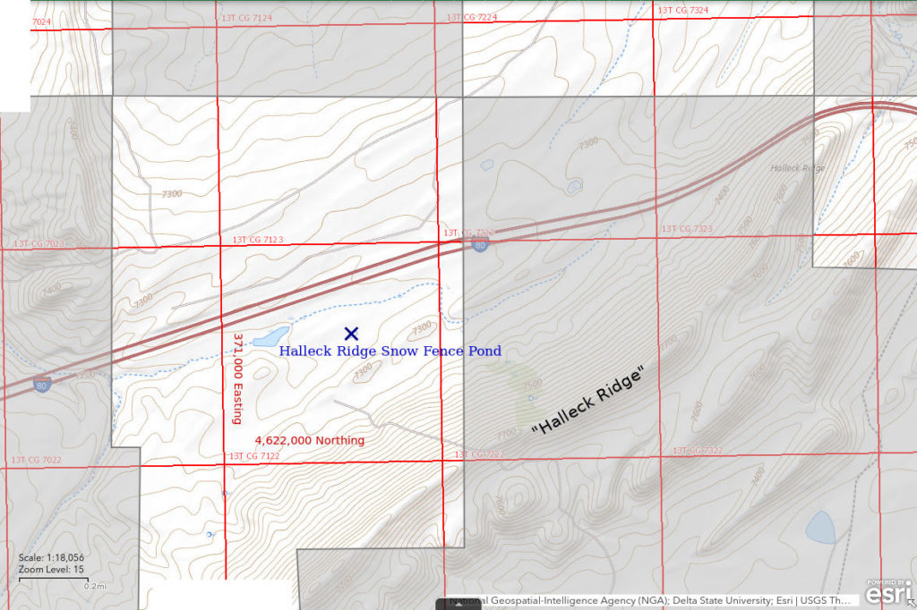
Halleck Ridge Snow Fence Pond
What Can We Learn from the Ponds near Elk Mountain?
Elk Mountain is probably not a good name for this small area between the Hanna Basin, the Medicine Bow Mountains, and the upper North Platte River valley but at least “Elk Mountain” appears on the official highway map of Wyoming and many other maps. Because I looked at only 1 pond in the Elk Mountain area, I won’t attempt to delineate the boundaries of my “Elk Mountain” area. Maps do show numerous off stream ponds north of Elk Mountain and west and northwest of the town of Elk Mountain. They make the area prospective for fairy shrimp but are mostly on private land.
Elk Mountain has an elevation of 11,156′ (3,400 m) according to the official highway map of Wyoming but the area around the mountain likely to have ponds is probably at 2,100-2,300 m (6,890′-7,550′). To the north and west of the Elk Mountain area, the towns of Medicine Bow, Hanna, and Walcott Junction have elevations of 6,583′ (2,010 m), 6,777′ (2,070 m), and 6,650′ (2,030 m), respectively (from official highway map of Wyoming).
Mean Annual Precipitation according to the Wyoming Climate Atlas by the Water Resources Data System and State Climate Office at http://www.wrds.uwyo.edu/sco/climateatlas/precipitation.html, Parameter-Elevation Regressions on Independent Slopes Model, PRISM, with 1971-2000 data at very widely spaced weather stations (I have eyeballed the values from a very small scale map with 11 precipitation bins marked with indistinct colors and further obscured by a shaded relief base map):
11″-15″ (28-38 cm)
Most of the area is dominated by sagebrush but Elk Mountain is forested with pine.
The Elk Mountain area is within the railroad checkerboard of alternating sections of private and public land and also has extensive ranches. Consequently, the area is inappropriate for most recreational activities. I-80 goes through the area.
Halleck Ridge Snow Fence Pond (Rawlins BLM Office)
___This map is a screenshot of The National Map (Go to The National Map). The U.S. Geological Survey generally does not copyright or charge for its data or reports (unless printed). A pond location is indicated by an “X”, which corresponds to the coordinates given in the data spreadsheet. Labels in quotations are from 7.5-minute topographic quadrangles.
___Red lines are the U. S. National Grid with a spacing of 1,000 m and intersection labels consisting of the UTM zone (e.g., 11S, 12T), a 2-letter 100-km square designation (e.g., LC, XN), and a 4-digit number. The first 2 digits of the number represent the 1,000-meter Easting and the second 2 digits the 1,000-meter Northing, as seen in the example Easting and Northing. Unlike latitude and longitude, the National Grid is rectilinear on a flat map, the units of abscissa and ordinate have equal lengths, and the units (meters) are measurable on the ground with a tape or by pacing.
___Gray shading represents private land as traced from the PAD-US 2.0 – Federal Fee Managers layer of The National Map. Other lands are public.

Halleck Ridge Snow Fence Pond is north of Elk Mountain and about 12 km (7.5 miles) northwest of the town of Elk Mountain. The pond is about 1.5 miles west of where the Interstate-80 crosses Halleck Ridge. It is shown with an intermittent lake symbol on the 7.5-minute topographic quadrangle. Halleck Ridge Snow Fence Pond is about 70 m (230′) long on USGS imagery, which is of unknown vintage. Halleck Ridge Snow Fence Pond is east of a snow fence.
A larger pond 325 m (1,070′) west of Halleck Ridge Snow Fence Pond is a helpful landmark. It is 50 m (160′) from the highway behind a small dam on the drainage immediately south of the highway. The length of the larger pond is 200 m (660′) long on USGS imagery.
Halleck Ridge Snow Fence Pond is along I-80 but there is no exit or turnout. You have to park on the shoulder. The location is about 5.3 miles west of exit 255 to Hanna and 14.7 miles east of exit 235 at Walcott Junction. Halleck Ridge Snow Fence Pond is approximately 200 m (660′) south of the highway. The pond is visible from the highway and the larger pond closer to the highway is even more visible.
Elevation: 2,208 m (7,245′)
May 31, 1989
The pond sure looks promising from the highway.
- Size and depth not estimated.
- Water clear.
- No fairy shrimp.
- A few beetles, damselfly larvae, ostracods, lots of cladocerans (some jumbo size), ducks, phalaropes.
What Can We Learn from the Ponds Near Elk Mountain?
There are numerous ponds in the Elk Mountain area below the mountain itself but most are on private land.
I looked in 1 pond and did not find fairy shrimp but the sample size is obviously too small to allow conclusions about the abundance of fairy shrimp in the area. The presence of ostracods and cladocerans in that pond suggests that the apparent absence of fairy shrimp is not due to physical or chemical constraints.