Railroad Southwest Pond #1
Railroad Southwest Pond #2
Railroad Southwest Pond #3
Little Cliff Ridge Pond #1
Little Cliff Ridge Pond #2
Little Cliff Ridge Long Pond
Raven Roost Reservoir
Railroad “Dry Lake” #1
Railroad “Dry Lake” #2
What Can We Learn from the Ponds in Railroad Valley?
Railroad Valley is a broad basin bounded on the southeast and east by the Quinn Canyon, Grant, and White Pine ranges and on the northwest and west by the Duckwater Hills and Pancake Range. The north end of the valley is pinched between the Pancake and White Pine ranges in the vicinity of the Duckwater Reservation but the headwaters of Bull Creek extend farther north to Mt. Hamilton. The northern part of the valley is of different character than the rest of the valley. The narrower width means it is mostly alluvial fans without mud flats. It is also at a higher elevation and has a north-south trend. The main, central part of the valley is wide, has extensive mud flats, has a southwest-northeast trend, and is sparsely vegetated with desert scrub. The southern end of Railroad Valley is also distinct. Maps apply the name Railroad Valley to the part that curves to the south around a northward spur of the Quinn Canyon Range, crosses a drainage divide and another sink with a playa, and then transitions to Monotony Valley west of Queen City Summit and south of Nevada 375. This southern part is lower in elevation than the central part, narrower, and has a south-north trend.
The official Railroad Valley is too big for my purposes. Instead, I refer to the broad, central part of the valley from the Bull Creek crossing of Nevada 379 southeast of the Duckwater Reservation to Buttes Well north of the north spur of the Quinn Canyon Range as Railroad Valley. This broad Railroad Valley is 77 km (46 miles) long and mostly 20-24 km (12-14 miles) wide.
Central Railroad Valley is outlined reasonably well by the 1,600 m (5,250′) contour in the northern half (on the Duckwater 1:100,000-scale BLM map) and the 1,500 m (4,920′) contour in the southern half (on the Quinn Canyon Range 1:100,000-scale BLM map). The 1:100,000-scale BLM map has spot elevations as low as 1,436 m (4,710′) within the stippled playa part of the valley. The playa is south of US 6 and measures about 17 km (10 miles) northwest-southeast and 12 km (7 miles) southwest-northeast.
Vegetation in Railroad Valley is rather sparse. In the southern part of the central valley, I saw greasewood, bud sage, littleleaf horsebrush, and rare shadscale but the mix likely changes from place to place. The soil is more sandy than clayey and that makes hiking somewhat more tiring.
The playa in central Railroad Valley is one possibility for fairy shrimp. Unfortunately, you would have to find your way past Wildlife Management Areas to its north or oil fields and farms to its east or take a long hike from the southeast to reach it. There is a narrow window between 2 Wildlife Management Areas west of the playa where the edge of the playa shown on the 1:100,000-scale map is less than 5 km (3 miles) from a maintained road. South of the southernmost Wildlife Management Area though the distance to the road widens to more than 10 km (6 miles). Another possibility is ephemeral ponds in the southern part of Railroad Valley. The 1:100,000-scale map shows a few and the 7.5-minute topographic quadrangles show several stippled areas for ephemeral ponds. Large, spring-fed perennial and intermittent ponds are shown on the 1:100,000-scale BLM maps north of the playa stipple and south of US 6. They have all been taken over by NDOW as Wildlife Management Areas.
Railroad Valley is mostly public land managed by the Tonopah Office of BLM. In the south, Big Creek Ranch covers 5 3/4 1-square mile sections (15 square km) with center pivot sprinklers and there is about a half-section (4 square km) of private land at nearby Nyala. There are other smaller blocks of private land around some of the springs on the east side of the valley and north, west, and southwest of Currant. Much of Duckwater Creek is private land for about 8 km (5 miles) south of the Duckwater Shoshone Reservation.
There is a well-maintained road on the east side of Railroad Valley south of US 6 and a rough, less maintained road on the west side. The road on the east side also provides access from Nevada 375 to the south. It is used by hay trucks. A road that goes southeast from Buttes Well joins the 2. There is a creek not far from Buttes Well that was running high when I visited. This was surprising as the creek comes out of the desert to the southwest, not out of the mountains. The ford had a firm bottom when I crossed but that might not always be the case.
Railroad Southwest Pond #1 (Tonopah BLM Office)
___This map is a screenshot of The National Map (Go to The National Map). The U.S. Geological Survey generally does not copyright or charge for its data or reports (unless printed). A pond location is indicated by an “X”, which corresponds to the coordinates given in the data spreadsheet. Labels in quotations are from 7.5-minute topographic quadrangles.
___Red lines are the U. S. National Grid with a spacing of 1,000 m and intersection labels consisting of the UTM zone (e.g., 11S, 12T), a 2-letter 100-km square designation (e.g., LC, XN), and a 4-digit number. The first 2 digits of the number represent the 1,000-meter Easting and the second 2 digits the 1,000-meter Northing, as seen in the example Easting and Northing. Unlike latitude and longitude, the National Grid is rectilinear on a flat map, the units of abscissa and ordinate have equal lengths, and the units (meters) are measurable on the ground with a tape or by pacing.
___Gray shading represents private land as traced from the PAD-US 2.0 – Federal Fee Managers layer of The National Map. Other lands are public.
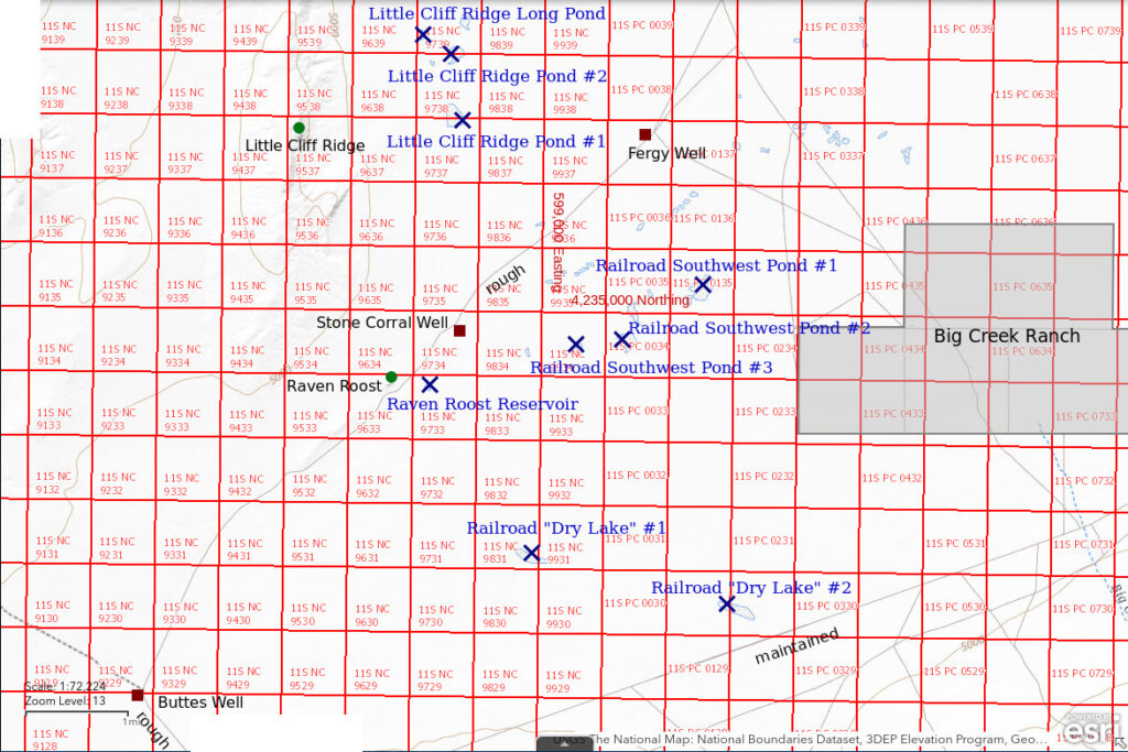
Railroad Southwest Pond #1 is shown on the 1:100,000-scale BLM map about 2.5 km (1.5 miles) south-southeast of Fergy Well, which is on the road on the west side of the valley. It is about 65 km (39 miles) southwest of Currant. The pond’s stippled area has dimensions of 360 x 580 m (1,180 x 1,900′) on the 7.5-minute topographic quadrangle. Although generally round it has floppy ears to the northeast and to the southwest. Without nearby landmarks, it is named southwest because it is in the southwestern part of Railroad Valley.
Elevation: 1,472 m (4,830′)
April 14, 2023
The northern part of Railroad Valley is cluttered up with Wildlife Management Areas, oil fields, and irrigated lands but, other than Big Creek Ranch, the southwestern part of the valley seems less disturbed. The 7.5-minute topographic maps show several intermittent ponds. I planned the day to look at several of them and this one is the first stop. I noticed the bud sage is blooming on the hike to the pond.
- Dry.
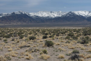
The white mud flat of Railroad Southwest Pond #1 with the Quinn Canyon Range in the distance to the east.
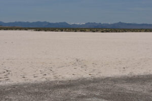
Railroad Southwest Pond #1 is all dry with no mud at all. This view is looking southwest. The mud cracks and hoof prints show it had water earlier this year.
Railroad Southwest Pond #2 (Tonopah BLM Office)
Railroad Southwest Pond #1 map
Railroad Southwest Pond #2 is another generally round but somewhat irregular pond about 1,200 m (3,900′) southwest of Railroad Southwest Pond #1. It is 190 x 240 m (620 x 790′) on the 7.5-minute topographic quadrangle. Like Railroad Southwest Pond #1, it is defined by a clay flat with a lack of vegetation.
Elevation: 1,476 m (4,840′)
April 14, 2023
A dry Railroad Southwest Pond #1 was not encouraging but I decided it is worth documenting other possible pond locations anyway. It’s a scenic hike in any case with views of the varied mountain ranges surrounding Railroad Valley. The leaves of desert mallow have appeared but no flower buds yet.
- Dry.
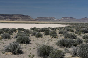
Looking northwest across Railroad Southwest Pond #2 with The Wall of the Pancake Range in the distance.
Railroad Southwest Pond #3 (Tonopah BLM Office)
Railroad Southwest Pond #1 map
Railroad Southwest Pond #3 is an elongate pond about 240 m (790′) long and 100 m (330′) wide on the 7.5-minute topographic quadrangle. It is approximately 1,930 m (6,330′) southwest of Railroad Southwest Pond #1 and considerably closer to Railroad Southwest Pond #2. The cluster of 3 Railroad Southwest ponds is east of the usually dry wash down the center of the valley and the valley floor is so flat they have minimal drainage areas. There are 2 other ponds close to these and several smaller ponds strung out between the wash and these ponds. Without looking at a map, there would be no reason to suspect there are ponds out here.
Elevation: 1,476 m (4,840′)
April 14, 2023
I’ve walked by several dry mud flats of various sizes so whatever weather resulted in a full “Lunar Lake” 19 km to the northwest didn’t help the ponds here.
- Dry.
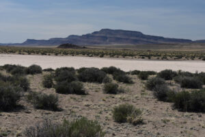
Railroad Southwest Pond #3 in a view to the southwest with the southern end of the Pancake Range in the distance. What a contrast between the table lands of the Pancake Range on the west side of Railroad Valley and the snowy, rugged mountains with temporarily rushing streams on the east side.
Little Cliff Ridge Pond #1 (Tonopah BLM Office)
Railroad Southwest Pond #1 map
Little Cliff Ridge Pond #1 is 3 km (1.8 miles) west-northwest of Fergy Well and 4.5 km (2.7 miles) northwest of Railroad Southwest Pond #1. It is 305 m (1,000′) long and the fatter south end is 260 m (850′) across. There is a south-north ridge 2.4 km (1.4 miles) to the west that has a small cliff on the east side.
Elevation: 1,472 m (4,830′)
April 14, 2023
Unlike the Railroad Southwest ponds, which are east of the dry wash at the bottom of the valley, this pond may have collected snowmelt from the ridge to the west.
- Dry.
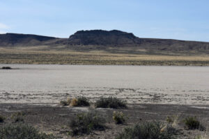
Little Cliff Ridge Pond #1. In the background is the little cliff on the ridge west of the pond. The cow hoof prints suggest that there was at least a little water here earlier this year.
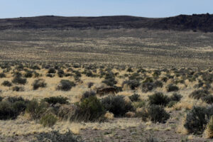
Coyote (below center) near Little Cliff Ridge Pond #1. It’s rare to walk up to a coyote without it seeing you first. It is even more uncommon to have time to get your camera out and take a photo. Even after it saw me, the coyote seemed to be more surprised than scared. It walked cautiously away for almost 50 m before taking off at a run.
Little Cliff Ridge Pond #2 (Tonopah BLM Office)
Railroad Southwest Pond #1 map
Little Cliff Ridge Pond #2 is 3.2 km (1.9 miles) northwest of Fergy Well and 700 m (2,300′) north of Little Cliff Ridge Pond #1. Its dimensions are about 190 m x 210 m (620 x 690′).
Elevation: 1,472 m (4,830′)
April 14, 2023
Spooked a horned lizard on the hike from Little Cliff Ridge Pond #1. I wouldn’t have seen it if it hadn’t darted off. Unlike lizards, which just keep running, horned lizards stop after a meter or 2 so you can almost always find them.
- Dry.
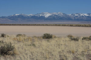
View to the northeast across Little Cliff Ridge Pond #2, with the Grant Range in the distance.
Little Cliff Ridge Long Pond (Tonopah BLM Office)
Railroad Southwest Pond #1 map
Little Cliff Ridge Long Pond is 3.2 km (1.9 miles) northwest of Fergy Well and 520 m (1,710′) northwest of Little Cliff Ridge Pond #2. It is 150 m long but only 40 m wide (490 x 130′). There is a slight slope to its west that could provide overland flow but no evidence of channels.
Elevation: 1,479 m (4,850′)
April 14, 2023
The coyote I saw earlier must have a family. As I approached this pond, I heard a lot of yapping. I tried to respond verbally but that made them go quiet.
- Dry.
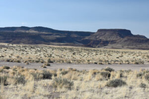
Little Cliff Ridge Long Pond. The shadows are already lengthening in the deep box canyon in The Wall.
Raven Roost Reservoir (Tonopah BLM Office)
Railroad Southwest Pond #1 map
Raven Roost Reservoir is 5.1 km (3.0 miles) southwest of Fergy Well and 4.4 km (2.6 miles) southwest of Railroad Southwest Pond #1. It is named for a small rocky hill 550 m (1,800′) to the west that had a raven circling around when I walked up it for the view. On the maps, the reservoir has a U shape that is 80 m across and 120 long (260 x 390′) with the arms opening to the south. On the aerial imagery and on the ground, it is not clear how far up the arms the water usually goes. Raven Roost Reservoir is located within the channeled area of the main wash down the valley. It is only about 250 m from the road on the west side of Railroad Valley.
Elevation: 1,482 m (4,860′)
April 15, 2023
I climbed up on Raven Roost to see if I could spot any water in the valley nearby. I saw several small, white, dry mud flats with no signs of water. Because the reservoir is on the map and so close to the road, I decided to collect GPS coordinates even if it is dry.
- The water is spread across about 10 m x 12 m; depth in the cow-pocks up to about 5 cm.
- Opaque pale brown water; ice crystal molds in the mud.
- Abundant fairy shrimp generally 10-30 mm long; some females have eggs.
- No other aquatic animals observed but the biting gnats are vicious.
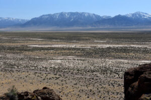
Looking east from Raven Roost. Raven Roost Reservoir is the white streak across the middle of the photograph. Everything else looks dry, too. The brown spot at the left end turned out to be wet mud. The road on the west side of the valley is in the foreground. The Grant Range in the distance is north of the snowier Quinn Canyon Range.
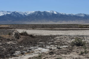
View southeast through the breached berm at the north end of Raven Roost Reservoir. The breach suggests the pond will never reach its former maximum size. If there was a fairy shrimp population here before the breach, it would be challenged by smaller future pond sizes. There is an area of darker, severely cow-pocked mud at center. The Quinn Canyon Range is in the distance.
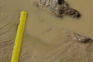
Cow-pocked mud in Raven Roost Reservoir. This is not what I expected. There is a fairy shrimp in about 1 cm of water and it is almost 30 mm long. The linear features in the mud are molds of ice crystals. Solidification of water is not good for fairy shrimp but maybe this fairy shrimp’s constant swimming kept this little dimple of water from freezing solid last night.
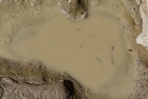
A few fairy shrimp swimming in opaque water in a small depression in the mud of Raven Roost Reservoir. The tubular distal segments about as long as the proximal segments of the antennae II of the 2 males at center are similar to those of Macari East Stop Sign Pond (“Carson Lake” Playa), Playa Wire Gate Pond (Soda Spring Valley), and Stinking Springs Well Pond (Rawhide Flats). The female at right has a pod of dark eggs.
Raven Roost Reservoir Fairy Shrimp Video 2023-04-15r, Railroad Valley.
For a 1-minute 51-seconds video of fairy shrimp swimming in what little water is left in Raven Roost Reservoir, click on the video player above. There is no audio. The video starts with a view to the southwest and then focuses on a patch of opaque water, where fairy shrimp become visible when they approach the surface, such as at 0:29, 0:38, 0:49-0:51, 1:15, and 1:38. There are actually quite a few of them.
Railroad “Dry Lake” #1 (Tonopah BLM Office)
Railroad Southwest Pond #1 map
Railroad “Dry Lake” #1 is 4.8 km (2.9 miles) south-southwest of Railroad Southwest Pond #1 and 12.7 km (7.6 miles) west-southwest of Nyala. It is closest to the road on the east side of Railroad Valley. On the maps, it is 550 m (1,800′) long and up to 135 m (440′) wide. It and Railroad “Dry Lake” #2 are labeled “Dry Lake” on the 7.5-minute topographic quadrangle, hence the quotation marks.
Railroad “Dy Lakes” #1 and #2 are curious features east of the wash down the middle of Railroad Valley. They could collect overland flow from the very gentle slope to their southwest as both have slight berms on their northern edges. The fact that they are long and their long dimensions line up in spite of the distance between them suggests they might be controlled by a fault scarp that has been mostly eroded away.
Elevation: 1,485 m (4,870′)
April 15, 2023
In driving from the road on the west side of the valley to get close to this pond, I was surprised to find a surging brown torrent in 1 of the channels of the wash down the middle of the valley. The source of the water was not obvious. “Echo Canyon Reservoir” by Nevada 375 on the east side of the Reveille Range is some 16 km (10 miles) away while snowmelt from Water Canyon, off the southwest end of the Quinn Canyon Range, has to cross about 12 km (7 miles) of porous alluvial fan to reach the main Railroad Valley wash about 1 km (0.6 miles) southwest of the ford. I had not seen water flowing in the wash near Raven Roost Reservoir this morning. This is quite a contrast to all the dry ponds I have visited. Wearing my rubber boots, I was able to wade the ford. The bottom was similarly firm enough to drive across. Otherwise, it would have been a long drive back to US 6 to the north.
- Dry.
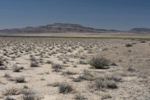
Railroad “Dy Lake” #1, looking west along the relatively straight northern edge of the pond. There is a slight rise to the right that could account for ponding of water. If that were a fault scarp, it has been eroded to almost nothing over a long period of time. The shrubs on the mud flat are saltbush (based only on the linear, involute leaves just coming out), which seems to be rare elsewhere in the vicinity. Their presence may indicate this pond very rarely gets water anymore. The Pancake Range is in the distance.
Railroad “Dry Lake” #2 (Tonopah BLM Office)
Railroad Southwest Pond #1 map
Railroad Dry Lake #2 is 1.8 km (1.1 miles) east-southeast of Railroad “Dry Lake” #1 and 9.9 km (5.9 miles) west-southwest of Nyala. It is 620 m long and up to 150 m wide (2,030 x 490′). It is only about 250 m (820′) from the east side road and is visible from the road.
Elevation: 1,484 m (4,870′)
April 15, 2023
Unlike Railroad “Dy Lake” #1, this one doesn’t have shrubs. The mud flat is almost blindingly white.
- Dry.
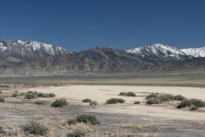
Railroad “Dy Lake” #2, looking east along the somewhat linear northern edge. The mountains in the distance are probably the northern Quinn Canyon Range but they could be the southern Grant Range, or both.
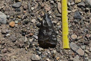
The dry lakes were a bit of a disappointment but I noticed this spear point about 100 m (330′) west of Railroad “Dy Lake” #2. The thrill of discovery is enough; I can let it lie.
What Can We Learn from the Ponds in Railroad Valley?
Railroad Valley has a very broad playa and many small mud flats that are potential fairy shrimp habitat.
8 of 9 mapped small ponds in the southern part of Railroad Valley were dry when I visited, even after a wet winter.
The 1 pond that had water may have received flow down a channel of the main wash earlier in the spring.
That 1 pond had fairy shrimp in puddles upstream of the breached dam that had previously created a stock watering reservoir. Future channel flows could wash the fairy shrimp egg bank down stream.