Petroglyphs
What Can We Learn from the Petroglyphs at Mount Irish Archaeological Site?
The Mount Irish Archaeological Site is on the east side of the Mount Irish Range 13 km (8 miles) west of Hiko. It was designated in 1970 and in 2015 was incorporated into the Basin and Range National Monument. It continues to be managed by the Caliente Office of the BLM and is minimally developed. There are a small sign or two and a turnout at a spot on the road from Hiko to Logan Pass over the Mount Irish Range. Hiko is on Nevada 318 just off US 93, which is the main route from Las Vegas to Ely.
When I visited the area, I had no knowledge of where to look for petroglyphs other than the 1-square-mile (260 hectares) area indicated on the 1:100,000-scale BLM map. Just wandering around though, I was able to find several petroglyphs. After I visited the area, I found a “Mount Irish Rock Art & Archeological District Trail Guide” online. This would be a very helpful guide to have in hand while visiting the site.
Petroglyphs

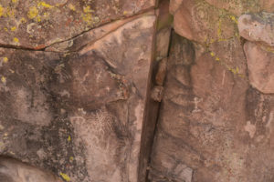
Petroglyph of fairy-shrimp-like figure near the Mt. Irish Archaeological Site, to left of fracture. The figure consists of a vertical line for the body, 5 curved cross-lines for the legs, additional lines perpendicular to the lowest cross-line which could be leg lobes (i.e., “leafy” legs or phyllopods), 2 short lines at an acute angle at the bottom of the body for cercopods, and 2 short curved lines angled toward the top for antennae I. This petroglyph is in the wash east of the archaeological site rather than within the site itself.
The 5 pairs of legs in the petroglyph are fewer than the 11 pairs most fairy shrimp have. However, some artistic license would be reasonable. Deer/elk petroglyphs rarely have more than 3 points (trail guide, page 8, figure 6), lizards have short tails (trail guide, page 16, figure 6), and bighorn sheep have less than half-curls (trail guide, page 17, figure 8). Moreover, it is difficult to determine details of fairy shrimp anatomy from visual observation of swimming individuals because the legs are always moving, or of those removed from the water because the legs become limp and formless.
I can’t think of any other animal that looks more like this figure than fairy shrimp. There are too many legs for vertebrates, scorpions, ants, and other insects. The curvature of the legs is also unlike most vertebrates. The parallelism of the cross-lines does not suggest branches of a tree or bush. Conceivably, the “cercopods” could be human legs and the antennae I human arms but what then are the wavy cross lines?

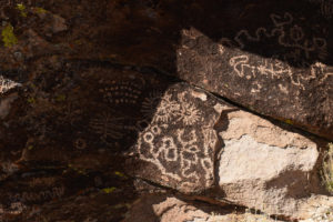
Petroglyph similar to fairy-shrimp-like petroglyph at Mt. Irish Archaeological Site. In the shadow at left is a vertical line with 5 perpendicular cross-lines, 2 questionable short lines at an acute angle at the bottom of the vertical line, and 2 short curved lines of unequal length angled toward the top. This cluster of petroglyphs is within the archaeological site and is shown on page 19 of the trail guide but is not described.
The above petroglyph is not as elaborate as the fairy-shrimp-like figure but it has obvious similarities. Does this mean the artist who made this petroglyph was not as skilled or not as diligent as the one who made the fairy-shrimp-like figure? Or was this artist satisfied with a more abstract depiction of fairy shrimp? Or did the artist who made the fairy-shrimp-like figure get carried away and add things that are not integral to the symbolism? Answers to such questions could support or weaken the case for fairy shrimp petroglyphs. The case for a human stick figure is even weaker for this less elaborate petroglyph.

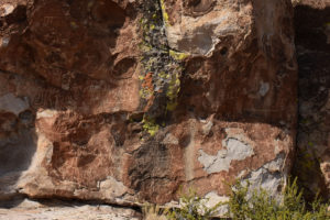
Petroglyph somewhat similar to fairy-shrimp-like petroglyph at Mt. Irish Archaeological Site. In the shadow to the right of center is a vertical line with 4 cross-lines. Below it is a simple cross. It lacks the short lines that could be cercopods or antennae but the multiple cross-lines suggest an affinity to the fairy-shrimp-like figure.
Vertical lines with multiple cross-lines are very rare at the Mt. Irish Archaeological Site. Without having seen the fairy-shrimp-like figure, I wouldn’t suspect this represents a fairy shrimp. It could be a geometric elaboration of a simple cross or maybe a representation of mulitple events, where a simple cross line indicates one event. If it symbolizes a fairy shrimp, it is greatly simplified. If it doesn’t, then whatever it does symbolize may also be the basis for the fairy-shrimp-like figure.

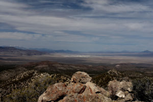
Is that food in the distance? Looking north from the northern part of the Mount Irish Range at the pale playa of Coal Valley at center. The playa is potential fairy shrimp habitat and is about 40 km (25 miles) north of the archaeological site.
I don’t know of any fairy shrimp habitat near the Mt. Irish Archaeological Site but there are several possibilities. Coal Valley is one. Others include the Sand Spring playa about 37 km (23 miles) to the west, the Dry Lake playa about 55 km (34 miles) to the east, and the Groom Lake playa about 52 km (32 miles) to the southwest. Fairy shrimp populations currently occupy similar habitat in Monitor Playa Lake (Monitor Valley), Rhodes Big Lake (Rhodes Salt Marsh), and Jungo Flat Playa Lake (Desert Valley) and in ponds near playas, such as Luning Playa Narrow Pond (Soda Spring Valley), North Smith Creek Playa Channel Ponds (Smith Creek Valley), and “Carson Lake” East Ridge Pond (“Carson Lake” Playa).
“Nesbitt Lake” and “Frenchy Lake” are 14-15 km (8.7-9.3 miles) to the southeast in the Key-Pittman State Wildlife Management Area. Nevada Department of Wildlife’s brochure for the area states that the Pahranagat wetlands south of Hiko historically supported native fish species. It’s possible that there were ponds in the area not connected to fish habitat that hosted fairy shrimp. The current hydrology of the wetlands is the result of human modification so the pre-settlement potential for fairy shrimp habitat at Key-Pittman is uncertain. A possible analogy is the spring-fed ponds of Smith Creek Cold Springs Ponds (Smith Creek Valley).
It is worth noting that the “Mount Irish Rock Art & Archeological District Trail Guide” does not mention fish.
A Paiute web page at www.newworldencyclopedia.org states that the Mono Lake band of Paiutes historically ate brine shrimp (fairy shrimp of the genus Artemia) and brine fly larvae from that lake. This suggests fairy shrimp could have been food sources for the Paiutes, Western Shoshones, their ancestors, or unrelated predecessors who carved the petroglyphs. As food animals are a common motif for petroglyphs, that would make interpretation of the the fairy-shrimp-like figure as a fairy shrimp more plausible.
Mount Irish Archaeological Site – top
What Can We Learn from the Petroglyphs at Mount Irish Archaeological Site?
If the petroglyph in photograph Mount Irish Petroglyph 2018-03-30, #28, is a fairy shrimp, fairy shrimp were probably present in east-central Nevada over the last 2,000 years or so. “Most of the petroglyphs are of the Great Basin Representational style (A.D. 1-1500) often depicting mountain sheep and deer” (The Mount Irish Rock Art & Archeological District Trail Guide, p. 20). Of course, fairy shrimp may have been present long before the Great Basin Representational style whether any human noticed them or not.