Kibby Flat Playa Lake
Kibby Triple Rut Pond
Kibby Fat Rut Pond
What Can We Learn from the Ponds in Monte Cristo Valley?
Monte Cristo Valley lies between the Pilot Mountains to the west and the Cedar Hills to the east. The Monte Cristo Range wraps around the southern part of the valley. A drainage divide separates Monte Cristo Valley from Stewart Valley to the north-northwest. Depending on where one puts the edge of the Monte Cristo Range, Monte Cristo Valley is 36-41 km (21.6-24.6 miles) long. The valley is mostly 10-15 km (6-9 miles) wide but narrows to about 5 km (3 miles) at the Stewart Valley divide.
The lower, southern part of Monte Cristo Valley is outlined rather well by the 1,700 m (5,580′) contour. A benchmark south of the center of the large intermittent lake symbol on Kibby Flat has an elevation of 5,266 feet (1,605 m) on the 7.5-minute topographic quadrangle. The National Map gives a spot elevation of 1,606.9 m (5,272′) at this location. The 3 ponds I visited in 2023 all had National Map spot elevations which rounded to 1,607 m. A peak in the eastern Pilot Mountains rises continuously from the valley floor to an elevation of 2,731 m (8,960′). The highest hill in the southern Cedar Hills east of Kibby Flat has an elevation of 7,163 feet (2,183 m).
The playa of Kibby Flat has scattered greasewood and greasewood dominates the lower elevations of Monte Cristo Valley. In contrast, sagebrush dominates at the Stewart Valley divide. In between, there is a mixture of shrubs, which also includes spiny hopsage, ephedra, and shadscale. The surrounding hills have few trees. Juniper appears at higher elevations in the Cedar Hills northeast of the valley. The Cedar Hills on the east side and the Monte Cristo Range to the south are almost treeless. Trees have been burned off parts of the eastern Pilot Mountains but sparse juniper occurs on the eastern slope of the southern Pilot Mountains and areas of pinyon-juniper woodland are present in the northern part of the eastern Pilot Mountains.
There are no paved roads and no private land in Monte Cristo Valley. There are a few wells for stock-watering scattered around and at least 1 derelict corral. There is a power line across the southern part of the valley. There are 2 “radio towers” adjacent to Monte Cristo Valley: one at the southern end of the Cedar Hills, and one at the northern end of the Pilot Mountains. There are 2 cattle fences across the valley north of Kibby Flat. There are a couple of old mines on the east side of the Pilot Mountains that actually produced something, several prospects that didn’t. An abandoned mill lies at the northwestern corner of Kibby Flat. As elsewhere in Nevada, there are numerous passable and impassable dirt roads in various stages of degradation. With only a paragraph of human impacts, Monte Cristo Valley seems relatively untrammeled.
Kibby Flat Playa Lake (Tonopah BLM Office)
___This map is a screenshot of The National Map (Go to The National Map). The U.S. Geological Survey generally does not copyright or charge for its data or reports (unless printed). A pond location is indicated by an “X”, which corresponds to the coordinates given in the data spreadsheet. Labels in quotations are from 7.5-minute topographic quadrangles.
___Red lines are the U. S. National Grid with a spacing of 1,000 m and intersection labels consisting of the UTM zone (e.g., 11S, 12T), a 2-letter 100-km square designation (e.g., LC, XN), and a 4-digit number. The first 2 digits of the number represent the 1,000-meter Easting and the second 2 digits the 1,000-meter Northing, as seen in the example Easting and Northing. Unlike latitude and longitude, the National Grid is rectilinear on a flat map, the units of abscissa and ordinate have equal lengths, and the units (meters) are measurable on the ground with a tape or by pacing.
___There is no private or state land on this map. All lands are public.
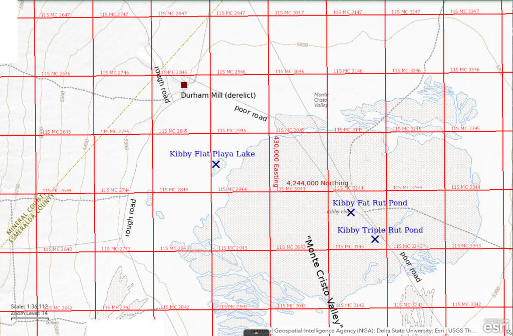
Kibby Flat Playa Lake is in the middle of the southern part of Monte Cristo Valley. The middle of the stipple pattern for the playa is 58 km (35 miles) northwest of Tonopah and 30 km (18 miles) southeast of Mina. The playa stipple pattern is 2.5 km x 4.5 km (1.5 x 2.7 miles) on the 1:100,000-scale BLM map. The place where I found water and collected GPS coordinates is not centrally located on the playa. It is northwest of most of the playa.
The best access to Kibby Flat Playa Lake is from US 95 at Mina. A relatively well maintained road turns east off US 95 700 m (2,300′) north of residences at the north end of town. This is 3.5 miles south of the turn-off to the fenced county dump/transfer station west of the highway and 1.2 miles north of the RV park at the south end of town. There are some ramshackle buildings and abandoned vehicles on both sides of this road less than 0.5 mile from the highway. The road leads past Mina’s wells and the “radio tower” at the north end of the Pilot Mountains. After passing the “radio tower” and crossing the divide into Monte Cristo valley, the access road forks. The northern fork goes to Stewart Valley and the Cedar Hills and the southern fork goes to Kibby Flat. The road to Kibby Flat becomes progressively more rocky and rough as it contours along the alluvial fans and some drainage crossings may be particularly rough. At the intersection 7.6 miles from the fork, turn to the southeast and down hill. It is 2.8 miles down the hill to the valley floor and a T-junction with the road that swings around the west side of Kibby Flat. Bear right (south) near the bottom of the hill to avoid driving into the wreckage of the Durham Mill. The northwestern edge of the playa’s stipple pattern is about 1.5 km (0.9 mile) from the T-junction.
There is a road around the west side of Kibby Flat that provides access to the western and southern parts of the playa. It is generally smoother than the access road across the alluvial fans. It connects to the Kibby Wells Road at the south end of the Cedar Hills. In the past, it was a relatively easy drive. In 2023, the road became a stream channel 2-4 miles west of the intersection with the Kibby Wells Road. It was probably still passable to 4-wheel drive vehicles but since I was pedaling a mountain bike, I didn’t pay attention.
The Kibby Wells Road crosses the middle of Kibby Flat Playa Lake but is only useful when the playa is dry. It extends from the Durham Mill to the south end of the Cedar Hills and from there goes around the east side of the Monte Cristo Range to US 6/US 95. It should go without saying that it should not be attempted when the playa is wet. When the playa is dry, ruts near the north edge of the playa are deep and dusty and present high-centering risks.
Elevation: 1,607 m (5,270′)
September 6, 2023
Hiking in the hills and bicycling in the valley around Kibby Flat made me aware of the potential for fairy shrimp. In the spring of 2019, after a wet winter, I paid a visit to look for fairy shrimp. I didn’t even find any damp mud so I wrote the area off as unpromising. Then, the summer of 2023 was so extraordinary that I found water and fairy shrimp in other locations where I didn’t expect them. Maybe it was time to give Kibby Flat Playa Lake another try. A week earlier I had found water on playas in Big Smoky Valley. On the way back, I had found fairy shrimp and tadpole shrimp in Kibby Wells Road Junction Pond in McLeans Valley. The abundance of water in Kibby Wells Road Junction Pond told me some big thunderstorms had hit the area. Kibby Flat is just over the hill. I drove to Kibby Flat within a week of visiting Kibby Wells Road Junction Pond.
- Local pond is about 100 m x 200 m but there may be others on the playa; depth not greater than 3 cm.
- Opaque pale brown water; 24 C in 1 cm water at 1030.
- Fairy shrimp 10-15 mm long; have eggs.
- Tadpole shrimp (Notostraca) 20-30 mm long, clam shrimp (Conchostraca) about 6 mm long, ducks, wading birds, plovers(?).
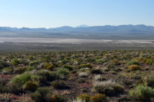
Looking southeast down the alluvial fan from the access road to Kibby Flat. Binoculars confirm the presence of water at the bright reflection at center, in the brush below the larger mud flat. The white spot at the left edge of the photograph does not appear to have water. This is the day.
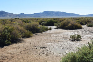
As I walk through the unseasonably green greasewood toward the reflection I had seen, the ground gets muddy. Then I see tiny puddles. It’s looking good. But what if this is all there is to the reflection?
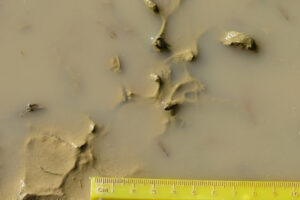
Well, the puddles have fairy shrimp. There is a fairy shrimp above the 3.5 mark on the ruler. The pair of large antennae II of a male can be seen at upper left. The dark, elongate shape in the upper right corner is also probably a fairy shrimp. I don’t know how long the eggs have waited for this but they are here and some have hatched.
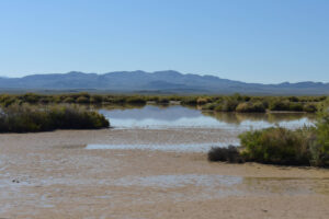
Kibby Flat Playa Lake, looking southeast with the Monte Cristo Range in the distance. This is a sizable body of water and likely caused the reflection I saw on the drive in earlier this morning. Fortunately, the mud is firm so I can walk around at ease. The extreme flatness of the playa and the big greasewood bushes make it impossible to see where other ponds may be but if this is all I find, I will still be elated.
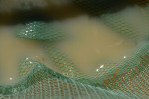
Fairy shrimp in the net at Kibby Flat Playa Lake. The fairy shrimp at right appears to have both an ovisac with pale eggs and an intestine with pale food. A pair of male antennae II are exposed at the surface of the water at left but the body can’t be seen. The water is so shallow that it took a long time to catch these fairy shrimp so that I could photograph them. Given how shallow the water is, if I had waited another 5 or 6 days, I likely would have missed everything. Fallon Experimental Station’s pan evaporation rate is 7.0 mm/day in August and 5.0 mm/day in September (see Pond Duration on the About page). Silver Peak’s is 13 mm/day and 9.3 mm/day.
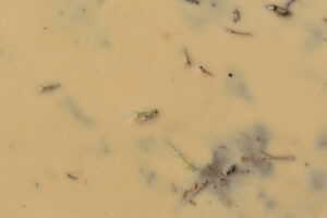
There’s more: several tadpole shrimp (Notostraca) at the edge of the water at Kibby Flat Playa Lake. There are tadpole shrimp at center, below center, above center, to left of center, and at lower right. The very narrow dark shapes are not tadpole shrimp or fairy shrimp.
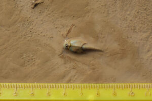
A tadpole shrimp (Notostraca) on the mud flat next to Kibby Flat Playa Lake. This tadpole shrimp makes photographing it easy as it plows over the mud with negligible water covering it.
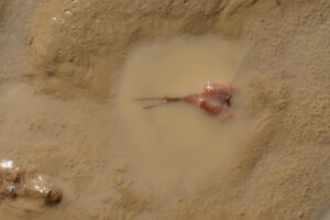
An inverted tadpole shrimp (Notostraca) on the mud flat next to Kibby Flat Playa Lake. The red legs suggest high hemoglobin content due to oxygen stress (Guadagnoli and others, 2005, p. 3550; see References page) so it may have flipped over to get a breath of air. A tadpole shrimp can push against the mud with its abdomen to flip itself over. This tadpole shrimp does not have a supra-anal plate at the end of its abdomen. This and the eye configuration and carapace markings seen on other individuals indicate the species is Triops longicaudatus. There is a carapace without a tadpole shrimp in the lower left corner. Maybe a bird ate the tadpole shrimp and left the carapace or maybe the tadpole shrimp died and disintegrated, as fairy shrimp do.
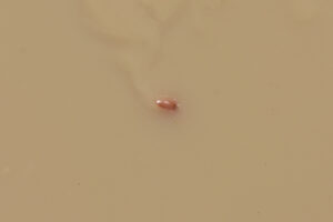
There’s more: clam shrimp in Kibby Flat Playa Lake. This clam shrimp is less than 10 mm long and is conveniently swimming close to the surface of the water, where I can photograph it. Kibby Flat Playa Lake is thus home to all 3 large branchiopod orders. However long the dry spells between fillings of the lake, they haven’t been long enough to kill off the branchiopod eggs.
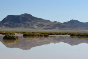
Kibby Flat Playa Lake and the southern Cedar Hills to the east. How did all these branchiopods get here? Maybe it was the birds. The windy day at Windy Gravel Pit Pond in McLeans Valley to the south demonstrated that winds could certainly disperse branchiopod eggs but birds are more selective about where the eggs get left, whether in feces or in mud that flakes off feathers or legs. This photograph shows 3 large wading birds and 2 small ones, one of which is next to the bush at left. 4 of the 5 birds have their beaks in or near the water. They are feeding on branchiopods.
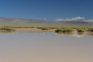
Kibby Flat Playa Lake and the central Cedar Hills. What is a duck doing in the middle of a desert at a pond with water that tastes like clay and is too shallow to float on? Probably eating branchiopods. Maybe Ducks Unlimited should start stocking playas with branchiopod eggs.
Kibby Flat Playa Lake Tadpole Shrimp Video 2023-09-06c-cmr
For a 4-minutes, 33-seconds video of tadpole shrimp (Notostraca) swimming in Kibby Flat Playa Lake, click on the video player above. There is no audio. The first 14 seconds show an overview of the lake and some birds, which are probably feeding on branchiopods. The first easily seen, swimming tadpole shrimp appears at 0:28. I follow a very visible tadpole shrimp at the surface of the water at 0:33-0:41. Walking through the lake, I scan back and forth trying to catch more tadpole shrimp in the video. Some scenes have a tadpole shrimp or 2 and some have none. Brownish debris occasionally seen floating on the surface of the water are carapaces without the tadpole shrimp, such as at 1:44-1:47 and 2:31-2:37.
Kibby Flat Playa Lake Tadpole Shrimp Video 2023-09-06d-cmr
For a 38-seconds video of a tadpole shrimp (Notostraca) swimming in Kibby Flat Playa Lake, click on the video player above. There is no audio. A tadpole shrimp swims into view at 0:11 and I try to follow it as it swims around through very shallow water. It disappears at about 0:32 but reappears at 0:36. Maybe it found something it liked in the mud.
Kibby Flat Playa Lake Tadpole Shrimp Video 2023-09-06e-mr
For a 1-minute, 21-seconds video of several tadpole shrimp (Notostraca) swimming around my net and boot in Kibby Flat Playa Lake, click on the video player above. There is no audio. The net is lying on the mud to demonstrate how shallow the water is. A tadpole shrimp swims by and I follow it to my boot, where there are other tadpole shrimp. I notice a tadpole shrimp that is particularly interested in the handle of my net as if it is trying to eat, or maybe just taste, it. Other tadpole shrimp swim around and 2 engage in sharp avoidance maneuvers at 0:36. 2 others swim on to the net mesh at 0:57 and 1 continues to explore it at 1:01-1:10.
Kibby Flat Playa Lake Clam Shrimp Video 2023-09-06a-mr
For a 1-minute, 21-seconds video of a clam shrimp (Conchostraca) swimming at the surface of Kibby Flat Playa Lake, click on the video player above. There is no audio. This clam shrimp has a persistent swimming behavior of spinning around in tight circles. At times, it even spins in place. Its velocity changes unpredictably, fast at times and slow at times.
Kibby Flat Playa Lake Clam Shrimp Video 2023-09-06b-cmr
For a 33-seconds video of a clam shrimp (Conchostraca) swimming at the surface of Kibby Flat Playa Lake, click on the video player above. There is no audio. This clam shrimp displays various swimming behaviors, spinning in circles of various diameters at times or just swimming around at other times. Tadpole shrimp swim by at right at 0:10-0:15. It looks like a tadpole shrimp dives below the clam shrimp at 0:23 to avoid it but the clam shrimp seems oblivious.
Kibby Triple Rut Pond (Tonopah BLM Office)
Kibby Triple Rut Pond is 3,010 m (9,880′) southeast of my location for Kibby Flat Playa Lake. It is 630 m (2,070′) southeast of Kibby Fat Rut Pond, which is close to the middle of the playa. On The National Map, the pond plots about 120 m (390′) southwest of the trace of the Kibby Wells Road. On the ground, it seemed to be within 10 m (33′) of the most used or most visible track across the playa. The ruts of Kibby Triple Rut Pond are not likely to endure more than a few years. Nonetheless, the pond demonstrates that when the playa is almost dry, searching for water in the vicinity of Kibby Wells Road could prove fruitful.
For access, see Kibby Flat Playa Lake. If most of the playa were flooded, there would be no Kibby Triple Rut Pond. It would be worth visiting only if the playa were almost dry and had only isolated puddles of water. If that were the case, the playa should be firm enough for walking to the pond from my location for Kibby Flat Playa Lake. If the playa is not firm, don’t bother. Look for other puddles that are easier to reach.
Elevation: 1,607 m (5,270′)
September 6, 2023
I had found water and all 3 large branchiopods in Kibby Flat Playa Lake but it would still be interesting to find deeper than average ponds that might retain water longer than the rest of the playa, like Playa Wire Gate Pond and Luning Playa Narrow Pond in Soda Spring Valley. Heading back to my vehicle along the tracks of the Kibby Wells Road, I found water in some the ruts. This is one of the deeper ones.
- The largest tire rut is 75 m long and up to 0.5 m across and there are 2 smaller, parallel ruts; depth up to 5 cm.
- Opaque pale brown water; 29 C in 2 cm water at 1530.
- No fairy shrimp.
- Rare tadpole shrimp (Notostraca) about 25 mm long.
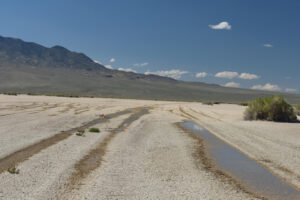
Looking across Kibby Flat playa with water in 3 ruts of the Kibby Wells Road in the foreground. This is Kibby Triple Rut Pond. The Pilot Mountains are at left. The presence of water here and at Kibby Flat Playa Lake 3 km away, not to mention the mud cracks and flakes, suggests that much of the playa was covered by water not too long ago. That would have been an awesome sight but thank goodness I at least got here in time to see the branchiopods.
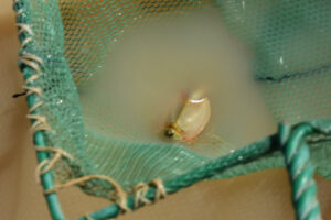
A tadpole shrimp (Notostraca) in the net at Kibby Triple Rut Pond. Here, tadpole shrimp seem to have outlasted fairy shrimp.
Kibby Fat Rut Pond (Tonopah BLM Office)
Kibby Fat Rut Pond is 2,440 m (8,010′) southeast of my location for Kibby Flat Playa Lake. It is near the middle of Kibby Flat playa as shown with the stipple pattern on the 1:100,000-scale BLM map and on The National Map. On The National Map, Kibby Fat Rut Pond plots 50 m (160′) to the southwest of the trace of Kibby Wells Road. On the ground, it is to the southwest of the most used or most visible track and its alignment diverges to the west from the main track. It appears to have been created by someone who turned off the main track and was driving toward the western edge of the playa. As in the case of Kibby Triple Rut Pond, Kibby Fat Rut Pond is likely to gradually fill in over time until its depth is not sufficient to preserve water much after the rest of the playa dries up.
For access, see Kibby Flat Playa Lake. Kibby Fat Rut Pond is worth visiting only when the playa is almost dry and the ground is firm enough to allow walking almost anywhere. As the locations of the deepest tire ruts are likely to change over the years, searching along the most visible vehicle tracks for any ruts with water is likely to be more successful than going to a particular tire rut.
Elevation: 1,607 m (5,270′)
September 6, 2023
Still following the vehicle tracks from Kibby Triple Rut Pond back toward my truck. I don’t remember how many rut puddles I looked at but all but a few lacked large branchiopods. That didn’t keep me from continuing to look.
- Tire rut 1.5 m x 30 m; depth up to 4 cm.
- Opaque brown water.
- No fairy shrimp.
- Tadpole shrimp (Notostraca) about 25 mm long.
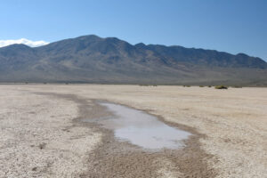
Kibby Fat Rut Pond on an otherwise dry, mud-cracked playa, with the Pilot Mountains in the distance.
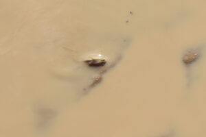
A tadpole shrimp exposed in very shallow water of Kibby Fat Rut Pond.
What Can We Learn from the Ponds in Monte Cristo Valley?
Kibby Flat Playa Lake has fairy shrimp (Anostraca), tadpole shrimp (Notostraca), and clam shrimp (Conchostraca, or the orders Spinicaudata, Laevicaudata, and Cyclestherida) but only rarely has water. All 3 were found at the same time in early September of the very wet 2023.
The tadpole shrimp are the species Triops longicaudatus, like those in Kibby Wells Road Junction Pond and Windy Gravel Pit Pond in McLeans Valley and in Garfield 5890 Saddle Pond in the Garfield Hills. They can be distinguished from Lepidurus tadpole shrimp in Middle Washoe County (e.g., Rowland Spring North Pond 2019-05-08, #30, Burnt Lake Mud Bar Pond 2019-05-07, #05) by the absence of a supra-anal plate (Pennak, 1978, p. 346-347).
Given the rarity of water on Kibby Flat and the distance from any other body of water, it’s a wonder water birds ever visit, but they do. Rhodes Grassy Pools at Rhodes Salt Marsh is probably the closest water body that would provide water bird habitat in most years. Rhodes Big Lake and Rhodes Potholes might, too, but TDS there is so high that only fairy shrimp of the genus Artemia have been found.