Monitor Playa Lake
Box Spring Roadside Pond
What Can We Learn from the Ponds in Monitor Valley?
Monitor Valley lies between the Toquima Range to the west and the Monitor Range to the east and has no towns or paved roads and only a couple of occupied ranches. To the south, low hills near the town of Belmont separate it from the Ralston Valley. To the north, Monitor Valley merges with Kobeh Valley as the Monitor Range terminates just south of US 50. The valley is 110 km (68 miles) long and mostly less than 13 km (8 miles) wide. The 1:100,000-scale BLM map shows a “Dry Lake” with an “intermittent lake” pattern in the central part of the valley south of Box Spring. There are no intermittent lake or stipple patterns in the northern part of the valley.
The flatter, central part of the valley south of the hills between Box Spring and Diana’s Punch Bowl is approximately defined by the 2,100 m (6,890′) contour. This contour outlines an area approximately 30 km (19 miles) long and up to 8 km (5 miles) wide. Most of this is playa with little or no vegetation. North of Diana’s Punch Bowl, there is no playa. The central valley floor slopes very gradually to the north, descending to 2,000 m (6,560′) at Stoneberger Creek and 1,910 m (6,270′) at US 50, 48 km (30 miles) to the north.
Monitor Valley is mostly covered by sagebrush on the alluvial fans. Sagebrush decreases and rabbitbrush, greasewood, and other desert shrubs increase in abundance toward the basin floor. Most of the basin floor lacks shrubs but is abundant at times.
Monitor Valley is mostly public land managed by the Mount Lewis Office of BLM but there are large blocks of private land: along Stoneberger Creek at Monitor Ranch, at the Potts Ranch and hot springs, at Johnson Hole and lower Mosquito Creek, on lower Pine Creek at the Pine Creek Ranch and to the north, and in the middle of the valley east of Waterfall Canyon. There are smaller parcels of private land at Potts well in the north, White Sage Spring, Diana’s Punch Bowl, Box Spring, the springs at the northeast end of the “Dry Lake”, at the mouth of East Northumberland Canyon, the Morgan Ranch on Morgan Creek just west of the National Forest boundary, a cluster of springs near Mosquito Creek, Stone House Ranch on Corcoran Creek, and Barley Creek Ranch on Barley Creek west of the National Forest boundary.
There is a county-maintained road along the full length of Monitor Valley that is passable to most vehicles except after flash floods. The north end intersects US 50 36 miles east of Austin and 33 miles west of Eureka. From the south, Belmont can be reached on a damaged paved road that branches off Nevada 376 13 miles north of US 6, east of Tonopah. The county-maintained road extends north from there.
Monitor Valley can also be reached via county-maintained roads from Nevada 376 in Big Smoky Valley except during adverse winter conditions. In the north, the Petes Summit road turns southeast off Nevada 376 less than 1/2 mile from US 50 and passes by Spencer Hot Springs before crossing the Toquima Range next to Toquima Cave and the Toquima Cave Campground. The Northumberland Mine Road turns off Nevada 376 about 5 miles south of the Kingston turn-off and 25 miles north of Carvers. It passes the TTT archaeological site in West Northumberland Canyon (not marked), the inactive Northumberland Mine (obvious open pit, etc.) at Northumberland Pass, and petroglyphs in East Northumberland Canyon (not marked) before entering Monitor Valley. The Moores Creek road takes a twisting route over the Toquima Range just north of the Mount Jefferson massif.
Monitor Playa Lake (Mount Lewis BLM Office)
___This map is a screenshot of The National Map (Go to The National Map). The U.S. Geological Survey generally does not copyright or charge for its data or reports (unless printed). A pond location is indicated by an “X”, which corresponds to the coordinates given in the data spreadsheet. Labels in quotations are from 7.5-minute topographic quadrangles.
___Red lines are the U. S. National Grid with a spacing of 1,000 m and intersection labels consisting of the UTM zone (e.g., 11S, 12T), a 2-letter 100-km square designation (e.g., LC, XN), and a 4-digit number. The first 2 digits of the number represent the 1,000-meter Easting and the second 2 digits the 1,000-meter Northing, as seen in the example Easting and Northing. Unlike latitude and longitude, the National Grid is rectilinear on a flat map, the units of abscissa and ordinate have equal lengths, and the units (meters) are measurable on the ground with a tape or by pacing.
___Gray shading represents private land as traced from the PAD-US 2.0 – Federal Fee Managers layer of The National Map. Other lands are public.
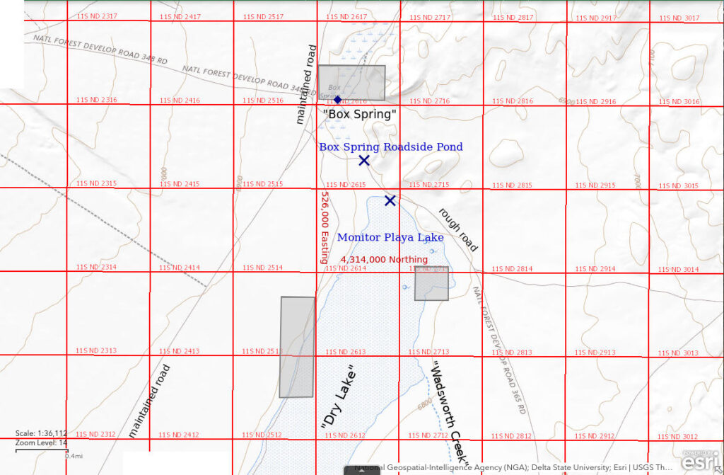
Monitor Playa Lake is 110 km (68 miles) northeast of Tonopah. The lake lies at an elevation of about 2,050 m (6,725′) in the central part of Monitor Valley. The 1:100,00-scale BLM map shows a “Dry Lake” here with an intermittent lake pattern 4.5 km long (14,760′) and up to 800 m (2,620′) wide. Water drains to this area from the south but can’t continue farther north because of the hills by Box Spring. There are springs at the northeast corner of the playa. The playa and potentially inundated areas are larger than the “Dry Lake” on the map.
The county-maintained road in Monitor Valley is generally 1-2 km (0.6-1.2 miles) west of Monitor Playa Lake. The best chance to get close to any water present is to turn east just south of Box Springs and go about 0.8 miles to the north end of the lake. There are other unimproved roads on the map that head into Monitor Playa Lake from the east and west to the south.
Elevation: 2,071 m (6,795′)
July 10, 2019
I saw the water from a nearby mountain and couldn’t resist. A playa in Nevada with water is not that common. My first approach to the playa was about 4 km (2.5 miles) south of the “Dry Lake” pattern on the map. The road turned off the Monitor Valley road about 500 m (1,640′) south of the road up Water Canyon (road #485 on the Humboldt-Toiyabe National Forest’s recreation map of the Austin Ranger District) to the west. The mud was too soft to reach the water even though it was already cracking. There were greenish-brown mats of algae or cyanobacteria about 10 m (33′) from the water’s edge but no white mineral crusts. I then turned off at Box Springs and followed the road east to a place that was about 100 m (330′) from the water. The edge of the playa, here at the north end, is relatively firm.
- More than 500 m wide and more than 5,000 m long; maximum depth uncertain.
- Water murky pale reddish-brown.
- Bimodal population of pale gray to reddish fairy shrimp with most 10-15 mm long and fewer 20-25 mm long.
- Lots of flies (alkali flies?); a few gulls.
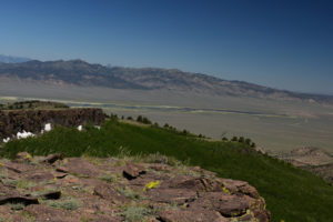
Water in Monitor Playa Lake with the Toquima Range in the distance, as seen looking northwest from the Morgan Creek trail up Table Mountain. The county-maintained road through Monitor Valley is on the far side of the playa.
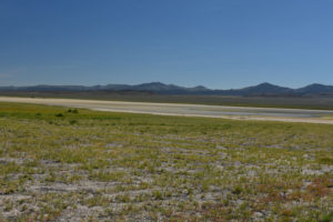
View northeast from near the southern end of Monitor Playa Lake, with the Monitor Range in the distance. I was unable to get to the water to check for fairy shrimp here. The abundant vegetation on the mud flats suggests the water was previously much more extensive. Note the abundant grass and lack of shrubs this close to the valley floor.
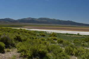
Looking southeast across the brown, wind-whipped water at the north end of Monitor Playa Lake, with Table Mountain in the distance at center. The green area at far left is where the springs at the northeast edge of the playa are. There are a few gulls near the water’s edge but they can’t be distinguished from the white caps behind them without considerable enlargement of the photograph. The white mineral crusts show the water has pulled back considerably and probably has high TDS now.
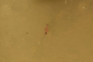
A female fairy shrimp of the smaller size class swimming close to the surface of the water in Monitor Playa Lake. The bulbous shape of the ovisac suggests this individual is of the genus Artemia (BTANSD). This one does not have a male holding on like some of the other females do.
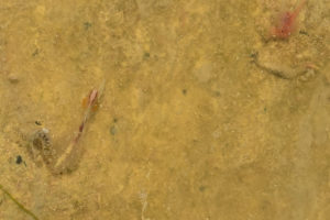
This large female in Monitor Playa Lake has an ovisac that is much longer than it is wide and is almost 3/4 the length of the abdomen. This indicates it is a different species than the female in photo Monitor Playa Lake 2019-07-10, #05. This fairy shrimp is barely moving. I don’t know what the gray segmented object to the left of the large female is but it could be an alkali(?) fly larva as hatched flies are abundant near the water. There is a smaller, pinker fairy shrimp at upper right.
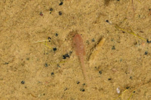
Male fairy shrimp of the larger size class in Monitor Playa Lake. The distal segments of the antennae II have thin, bladed shapes and lengths almost as great as the fatter basal segments. These features indicate the larger fairy shrimp are not of the genus Artemia.
It turns out I happened to visit Monitor Playa Lake when 2 species of fairy shrimp were present. The smaller species is characterized by females with short, bulbous ovisacs and by many male-female pairs swimming together as the male clasps the female with its antennae II (BTANSD). These features are like the fairy shrimp I sampled in Wyoming at “Steamboat Lake” 2nd East Pond (Granite Mountains) and Screeching Avocets Pond (Great Divide Basin), for example. Such fairy shrimp were identified as the genus Artemia by Denton Belk. Artemia species are restricted to high-TDS water and the white mineral crusts around Monitor Playa Lake indicate it does have water with high TDS.
The larger species is characterized by females with long ovisacs and males with long, bladed distal segments of antennae II. Fairy shrimp I collected in Wyoming that were identified as Branchinecta campestris by Denton Belk also have long ovisacs and long, bladed distal segments of antenna II (BTANSD). B. campestris has been collected from high-TDS water and has been found in ponds at the same time as Artemia fairy shrimp (e.g., Lynch, 1960, and Rogers and Hill, 2013, p. 256; see the References page). Denton Belk identified both Branchinecta campestris and Artemia in samples I collected from Long Pond and Screeching Avocets Pond in the Great Divide Basin. This is permissive evidence that the larger fairy shrimp in Monitor Playa Lake are B. campestris but there may be other species which also have these characteristics.
The summary of Belk (1975) lists Artemia salina but not Branchinecta campestris as occurring in Nevada. Artemia salina has more recently been reclassified as Artemia franciscana (as explained by Ruebhart and others, 2008, for example). Artemia franciscana occurs throughout the western United States. Belk (1975) noted that Branchinecta campestris had been reported in Texas, Washington, and Wyoming. It has been more recently discovered in California (Belk and Serpa, 1992).
The smaller fairy shrimp are swimming more vigorously than the larger fairy shrimp in Monitor Playa Lake. Some smaller and larger fairy shrimp appear to be dead or dying near the water’s edge where the water does not completely cover their bodies. They may have been pushed to their locations by wave action and been unable to swim back out to deeper water. In general, the larger fairy shrimp seem moribund. It may be that the TDS in the lake has increased to toxic levels for them due to evaporation. If the smaller fairy shrimp are Artemia, they could survive until the playa lake is almost dry.
March 2, 2022
After the heavy December snows, fairy shrimp hatched in January in the lower-elevation Soda Spring Valley. Is there still enough water and has it warmed up enough for fairy shrimp to hatch here? There is plenty of water but my boots are sinking up to 15 cm (6″) in the mud close to the lake. Grassy areas provide slightly more support but don’t extend into the lake. I can’t stop walking for fear of sinking even deeper so I have decided not to push my luck. I wonder if snowshoes would help.
I can see white, centimeter-size bits of material floating on the lake water. They are likely minerals but could be ice.
I think at least one of the 3 springs shown on the 1:100,000-scale BLM map at the northeast corner of the playa lake is exposed above the water. It is a disk of thick ice about 20 m (66′) across in a broad grassy area. Ice is rare elsewhere around the lake. There is an ice-free area about 2 m (7′) across in the middle of the ice with green grass and clear water and no mineral crusts. I made the mistake of stepping off the ice and went in up to my knee.
- Maybe 500 m wide and greater than 2,000 m long; maximum depth can’t be determined due to difficult access.
- Water in puddles near the shore ranges from clear to cloudy in various shades of brown to pink and reddish brown.
- Presence of fairy shrimp unknown due to difficult access but none seen in puddles along the shore.
- Killdeer.
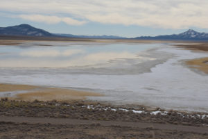
View to south across Monitor Playa Lake, with access road in foreground. From the dry shore toward the lake, there is a zone of mud with orange-brown grass; a broad, discontinuous zone of soft mud coated with up to 1 cm of whitish-gray mineral precipitate; an irregular zone of very soft mud with puddles and pockmarks of water up to about 8 cm deep with or without mineral crusts; and the smooth surface of the lake, which I never got to.
August 31, 2023
There was so much water visible from the road coming out of East Northumberland Canyon from Big Smoky Valley I decided to check out the southern end of the mud flat first. I turned southeast off the Monitor Valley road onto a 2-track road along a fence about 500 m (1,640′) south of the road to Water Canyon (road #485 on the Humboldt-Toiyabe National Forest’s recreation map of the Austin Ranger District). The road reached the mud flat at the southern edge of the water, more or less. This means there is about as much water as when I visited in July 2019, if not more. Where the water covered grass, I sank only about 5 cm (2″) into the mud. The mud softened significantly away from the water’s edge. Consequently, I thought I would have better luck at the north end of the playa. At the north end of the playa, submerged, thread-like vegetation extended far away from the shore. Although the vegetation provided marginally adequate footing, the water got to the tops of my boots before I reached open water.
- Probably 1,000 m or more wide and 8,000 m long (but length continuity not verified); maximum depth not estimated but greater than 20 cm.
- Clear water associated with submergent vegetation and on mud flat at south end until wind picked up, otherwise cloudy to opaque.
- Fairy shrimp not in near-shore vegetated area.
- Black masses of alkali(?) flies, water boatmen (on mud flat), snowy plovers (on mud flat), killdeers.
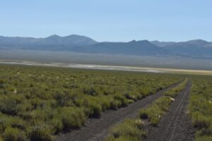
The road leading to the south end of the water in Monitor Playa Lake, looking southeast to Monitor Range.
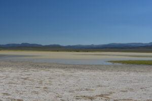
View to northeast across Monitor Playa Lake. Mud near the grass at right is relatively firm but it softens quickly into the water. Mud in the foreground has a mineral crust. The pale yellow water has high turbidity and ripples due to the wind.
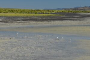
View north along the western shore of Monitor Playa Lake. After checking my Audubon field guide, I think the birds are snowy plovers.
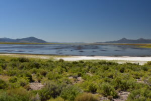
Monitor Playa Lake, in view looking south similar to Monitor Playa Lake 2022-03-02, #02 but from the edge of the access road rather than from above it. There could well be fairy shrimp out there but the water is too deep for me to get to them. There is dense, submerged vegetation 10s of meters from the shore.
Box Spring Roadside Pond (Mount Lewis BLM Office)
Box Spring Roadside Pond is along a bend in the road southeast of Box Spring and northwest of the north end of Monitor Playa Lake. The water is on the southwest side of the road. The water does not come from Box Spring. It is isolated from the northern shore of Monitor Playa Lake by more than 200 m (330′) of greasewood-covered mud flat. It is possible that there is a channel across the mud flat that I did not see that connects the pond directly with Monitor Playa Lake. Of course, the pond also receives run-off from the road and adjacent terrain.
For access, see Monitor Playa Lake. The pond is adjacent to the road past Box Spring and around the north end of Monitor Playa Lake.
Elevation: 2,071 m (6,790′)
August 31, 2023
I had been here twice before so the size of the pond was a shock. The fullness of Monitor Playa Lake suggests the mid-August thunderstorms dumped considerable water here. This pond probably owes more to the thunderstorms than to a possible overflow from Monitor Playa Lake. However, the mud flat between the pond and the lake locally has streaks of water less than 2 cm deep and several meters across and there are numerous superficial channels on the mud flat that indicate water may have flowed from Monitor Playa Lake.
- Approximately 105 m long and up to 2 m wide; up to 15 cm deep.
- Water is opaque.
- Pale green fairy shrimp 10-12 mm long; they have eggs.
- Black diving beetles, water boatmen.
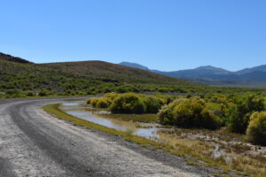
Box Spring Roadside Pond, looking southeast. The rabbitbrush is blooming.
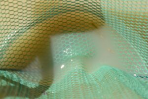
A few fairy shrimp in the net at Box Spring Roadside Pond. The eggs are visible through the cloudy water even if the bodies aren’t.
What Can We Learn from the Ponds in Monitor Valley?
A roadside pond and the playa lake in southern Monitor Valley have fairy shrimp.
2 species of fairy shrimp which can tolerate high TDS concentrations inhabit Monitor Playa Lake and their life spans sometimes overlap. Although species cannot be conclusively identified from non-microscopic observations, macroscopic and behaviorial characteristics indicate one species is probably Artemia franciscana and the other may be Branchinecta campestris.
Searching Monitor Playa Lake for fairy shrimp can be difficult. The mud was too soft in early March of the relatively dry 2022. Water less than knee-deep had dense submerged vegetation that would be inhospitable to fairy shrimp in late summer of the very wet 2023. No fairy shrimp were seen then although they may have been present in deeper water. Fairy shrimp were found in the playa lake only on the early July visit of the wet 2019 when the northern shore was firm enough for wading 10s of meters into the water and fairy shrimp were present essentially to the water’s edge.