Jungo Flat Playa Lake
What Can We Learn from the Ponds in Desert Valley?
Desert Valley extends for almost 80 km (50 miles) north from a low divide with the Humboldt River Valley north of Rye Patch Reservoir to somewhere not far south of the Quinn River. It is bounded to the west by the Jackson Mountains and to the east by the Eugene Mountains and Slumbering Hills. Desert Valley is mostly 15-25 km (9-16 miles) wide. The Quinn River does not drain into Desert Valley. A topographic valley continues from Desert Valley across the Quinn River and becomes Kings River Valley farther north.
The 1:100,000-scale BLM map shows only 3 areas of Desert Valley with the stipple pattern that indicates a playa. They are north, east, and south of the Jungo Hills on the west side of the valley north of Jungo Road. This understates the potential of the valley as broad inundated areas can sometimes be seen on both sides of Jungo Road south of the stipple patterns.
Extensive sand dunes extend from Desert Valley through the 10 km (6 miles) broad topographic low south of the Slumbering Hills into Silver State Valley. The 1:100,000-scale BLM maps show numerous stipple patterns in this area. They are sand, not playa. Nonetheless, there may be interdune ponds like in Killpecker Dunes.
The elevation of the valley floor is 1,250-1,300 m (4,100′-4,270′). The divide at the south end of the valley between Aloha Mountain and Haystack Butte is just below the 1,300 m contour. The contour spacing is too wide to precisely locate the northern divide but it is also below 1,300 m. Alluvial fans rise to about 1,500 m (4,920′) on the sides of the valley. The high point in the Eugene Mountains is 2,295 m (7,530′). King Lear Peak in the Jackson Mountains is 2,720 m (8,920′).
Vegetation on the valley floor is desert scrub.
The southern part of Desert Valley is part of the checkerboard of alternating sections of private and public land along the railroad. The public lands are managed by the Humboldt River Office of the BLM. There are a few section-size blocks of private land north of the checkerboard. A block of about 6 sections of private land near the northern end of the valley has several wells according to the 1:100,000-scale BLM map and probably has hay fields irrigated by pumped groundwater.
In addition to the well-maintained Jungo Road across the southern part of Desert Valley, Nevada 140 passes north of the valley near Quinn River from US 95 to Denio.
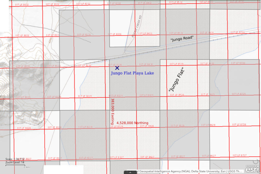
Jungo Flat Playa Lake (private)
___This map is a screenshot of The National Map (Go to The National Map). The U.S. Geological Survey generally does not copyright or charge for its data or reports (unless printed). A pond location is indicated by an “X”, which corresponds to the coordinates given in the data spreadsheet. Labels in quotations are from 7.5-minute topographic quadrangles.
___Red lines are the U. S. National Grid with a spacing of 1,000 m and intersection labels consisting of the UTM zone (e.g., 11S, 12T), a 2-letter 100-km square designation (e.g., LC, XN), and a 4-digit number. The first 2 digits of the number represent the 1,000-meter Easting and the second 2 digits the 1,000-meter Northing, as seen in the example Easting and Northing. Unlike latitude and longitude, the National Grid is rectilinear on a flat map, the units of abscissa and ordinate have equal lengths, and the units (meters) are measurable on the ground with a tape or by pacing.
___Gray shading represents private land as traced from the PAD-US 2.0 – Federal Fee Managers layer of The National Map. Other lands are public.

Jungo Flat Playa Lake is on the floor of Desert Valley in the vicinity of the site of Jungo, on the railroad 36 miles west of Winnemucca (according to the Nevada State Highway map). The 1:100,000-scale BLM map does not have any stipple pattern or other intermittent lake pattern in this area. Due to poor notes, the location shown on the map above and the coordinates in the data spreadsheet (on the Data page) may be more than 200 m (660′) from where I actually looked in the lake. That probably doesn’t matter as the water was extensive at the time.
The location where I looked at Jungo Flat Playa Lake is evidently on a private section within the railroad checkerboard. Property boundaries are not marked in this area.
Access to Jungo Flat Playa Lake is easy. Follow the Jungo Road west from Winnemucca. The Jungo Road follows the Union Pacific railroad across Desert Valley but deviates from it closer to Winnemucca. Like the railroad, the non-paved road continues south of the Black Rock Desert to the west and eventually reaches Gerlach. The road was well-maintained and treated with magnesium chloride by mining companies in the 1990s. Nonetheless, the road can become quite slippery during precipitation events and potholes form after heavy traffic.
Elevation: 1,271 m (4,170′)
April 23, 1998
Water on the playa was unexpected but NPPWOPII. I took a photograph but inadequate notes.
- Water more than 500 m across and possibly more than 1,000 m across; deepest depths measured at 3 cm but mostly less than 2 cm.
- Opaque pale brown water; thin ice at 0730.
- Fairy shrimp abundant with a trimodal, or possibly continuous, distribution of sizes: about 20 mm, 10-15 mm, less than 10 mm.
These were the first fairy shrimp I found in Nevada. Fairy shrimp were far from my mind at the time. I knew from Brown and Carpelan (1971; see the References page) that fairy shrimp occur on desert playas so when I saw all the water on Jungo Flat I couldn’t quite resist. I didn’t know the water was frozen when I stopped. That gave me pause but since I was already standing at the edge of the water, WIDLA.
I collected a few fairy shrimp along with playa water for later observation. I had hoped algae and bacteria in the water would be sufficient to keep them alive for more than a week but that proved not to be the case. The playa probably dried up in another couple of days anyway so I’m hopeful I did no harm. On April 28th, I examined some of the dead fairy shrimp under a binocular microscope. The distal segment of the male antenna II is cylindrical and has a blunt end without a twist or foot. There is a small, medial peg on the proximal part of the basal segment (criterion used by Belk, 1975). This appearance (BTANSD) is similar to that of Branchinecta mackini that I collected in Wyoming and was identified by Denton Belk. Large females have numerous eggs in ovisacs 1/2 to 3/4 the length of the abdomen and this is also consistent with identification as B. mackini.

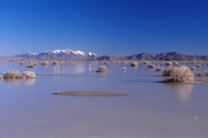
Looking northeast across Jungo Flat Playa Lake, with Blue Hills at right and probably the Santa Rosa Mountains on the horizon, with snow, at left. There is ice on most of the water’s surface. Mounds with greasewood bushes provide stepping stones for greater exploration of the water’s denizens.
What Can We Learn from the Ponds in Desert Valley?
On one chilly April morning, mature fairy shrimp were swimming under a mostly ice-covered surface near the Jungo Road.
Multiple generations hatched in early spring 1998 in keeping with the pattern I observed on “Carson Lake” Playa, Rawhide Flats, and Garfield Hills in winter 2022.
There are gulls at the Winnemucca dump. Some may visit Desert Valley when there is water and drop off fairy shrimp eggs from somewhere else.
Animal dispersal agents may not be necessary. The BLM brochure “Black Rock Desert – High Rock Canyon Emigrant Trails National Conservation Area, The Black Rock Playa” states that fairy shrimp and tadpole shrimp occur on the Black Rock Desert. Desert Valley is about 50 km (30 miles) east of Black Rock Desert, or less the farther north you go. Westerly winds are common. Fairy shrimp eggs could have been blown from the Black Rock Desert to Desert Valley on one of those days the National Weather Service refers to as “blowing dust”.