“Snow Water Lake”
What Can We Learn from the Ponds in Clover Valley?
Clover Valley lies east of the East Humboldt Range and west of the Wood Hills and Spruce Mountain Ridge. To the north, it terminates about 10 km (6 miles) south of Wells. To the south, a low divide west of Spruce Mountain separates it from Butte Valley. The result is a valley 53 km (32 miles) long and up to about 20 km (12 miles) wide.
Elevations in Clover Valley range from about 1,760 m (5,770′) south of Wells to 1,860 m (6,100′) on the Butte Valley divide and to about 1,700 m (5,580′) between Wood Hills and Spruce Point. The low point is in “Snow Water Lake” at about 1,705 m (5,595′). On the west side, the base of the East Humboldt Range is approximated by the 2,000 m (6,560′) contour. The valley is bounded by considerable relief. Peaks of the East Humboldt Range reach 3,250 m (10,660′). Spruce Mountain is 3,128 m (10,260′). The highest peaks in the Wood Hills are about 2,500 m (8,200′).
Vegetation around “Snow Water Lake” is desert scrub dominated by greasewood. Off the clay flats and particularly on the alluvial fans, sagebrush is king. Juniper occurs on the lower slopes of Spruce Mountain and East Humboldt Range. The northern half of Clover Valley has been extensively developed for agriculture. Stacks of hay visible from the highway suggest alfalfa is the principal crop.
Only the southern part of Clover Valley is public land. This includes “Snow Water Lake” and lands to the south and west of it. Along US 93 and to the west, the northern part of the valley is a solid mass of private land. This transitions eastward to railroad checkerboard. The western 1.5 km (0.9 mile) of the lake is at least 500 m (1,640′) south of private land. Then there is a private checkerboard section only 100-200 m (330-660′) north of the lake. Farther east, the lake is more than 1 km (0.6 mile) south of private land. A separate large block of private land extends east of US 93 at Warm Springs for 4 km (2.4 miles) south of the lake. It is at least 500 m (1,640′) south of the shoreline shown on the BLM map.
US 93 passes along the west side of Clover Valley and “Snow Water Lake”. The 1:100,000-scale BLM map does not show any roads that provide close access to the northern or eastern parts of “Snow Water Lake”. The BLM map does have a road that passes within 1 km (0.6 mile) south of the lake but getting to that road may be blocked by private land. The road is close to the historical location of the Hastings Cutoff of the California-Oregon Trail. The Hastings Cutoff gained fame and Lansford Hastings infamy because the Donner-Reed group of wagons followed it in 1846 before getting stuck in the snows of the Sierra Nevada.
“Snow Water Lake” (Elko BLM Office)
___This map is a screenshot of The National Map (Go to The National Map). The U.S. Geological Survey generally does not copyright or charge for its data or reports (unless printed). A pond location is indicated by an “X”, which corresponds to the coordinates given in the data spreadsheet. Labels in quotations are from 7.5-minute topographic quadrangles.
___As of April 2025, the National Grid overlay with red lines in UTM coordinates does not load in The National Map.
___Gray shading represents private land as traced from the PAD-US 2.0 – Federal Fee Managers layer of The National Map. Other lands are public.
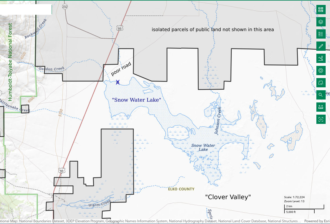
“Snow Water Lake” is in Clover Valley close to the east side of the East Humboldt Range 33 km (20 miles) south of Wells. It has an irregular, elongated shape that is about 8 km in a west-northwest to east-southeast direction and up to 2 km wide (4.8 x 1.2 miles). The lake receives inflows from the East Humboldt Range to the northwest, from Spruce Mountain to the southeast, and from the Wood Hills to the northeast. The 1:100,000-scale BLM map shows many streams disappearing before reaching the lake and all are intermittent in any case. In spite of its size, “Snow Water Lake” is shown as an intermittent lake on the BLM map. Aerial photography of The National Map shows that the lake does go dry.
Lake bottom stability may well vary along the more than 20 km (12 miles) long shoreline of Snow Water Lake” but finding the best location for wading would be difficult. Instead, I offer an anecdote. Angular, coarse sand and small pebbles occur in places along the northern shore within about 1 km (0.6 mile) of the western end of the lake. They are dispersed rather than concentrated, more like a debris flow than a stream deposit. As a result, they do not necessarily add stability to the muddy lake bottom. Nevertheless, in a few cases they do. The presence of the coarser sediment can be seen through water shallower than about 5 cm as scattered bits of pale rock or as a general gray color darker than the much more abundant white clay.
The northwestern tip of “Snow Water Lake” is within a few to several hundred meters (hundreds to thousands of feet) of US 93, depending on lake level. Conveniently, there is a poor road that turns off US 93 at its closest approach to the lake. The turn-off is 8 miles north of the intersection of US 93 and Nevada 229 and 1.2 miles south of the southern (2nd) junction of US 93 and Nevada 232. High-clearance vehicles can drive through the gate in the barbed wire fence and over the ruts for 100 m (330′) or so, depending on conditions. Public lands are east of the fence and private lands to the west. Normal passenger vehicles may need to park west of the fence or on the highway shoulder where it is flat enough to get well away from the pavement.
Elevation: 1,706 m (5,600′)
April 23, 2025
While hiking in the East Humboldt Range in early May a few years ago, I noticed a very large lake in the valley to the east. It was so close to US 93 that I could easily stop by on my way home. The mud above the shoreline was very soft. Because I didn’t have my rubber boots, I couldn’t even get to the water. I did see an avocet and took that as a good sign. I’m earlier this time and I’ve got my rubber boots.
- Map dimensions 2,000 m x 8,000 m; I got to a depth of 10 cm before the mud got too soft.
- Opaque off-white water; 12 C at 1715 in 2 cm water.
- No fairy shrimp.
- Gulls, wading birds that may be willets.
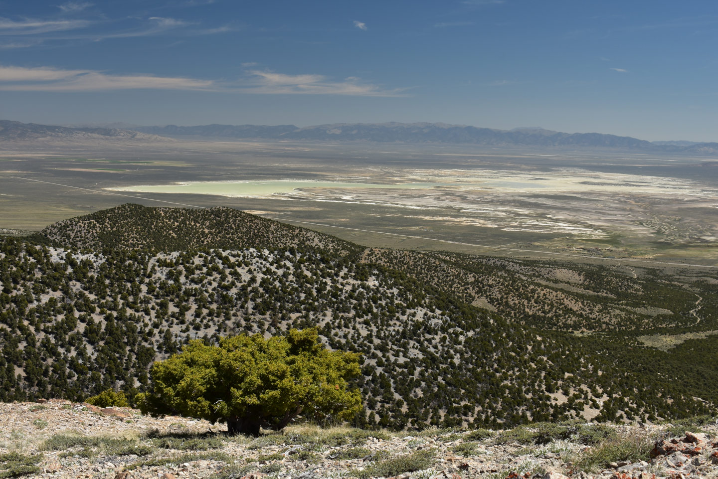
“Snow Water Lake” from southern East Humboldt Range. The water is faintly tinted greenish-gray and is rimmed by a thin white band of dry clay. The highway on the near side of the lake is US 93.
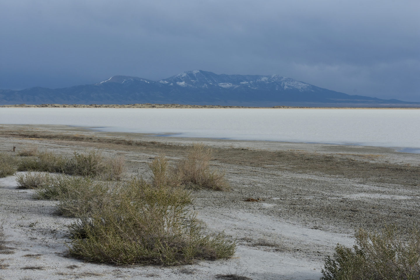
Looking south across “Snow Water Lake” to Spruce Mountain on a stormy, windy day. The water is white with churned up clay. In addition, because the water is being blown up onto dry clay along the western and northern shores, there are ripped up chips of formerly dry clay suspended in the water. I caught many of these in the net. There are green leaf buds on some of the greasewood bushes in the foreground.
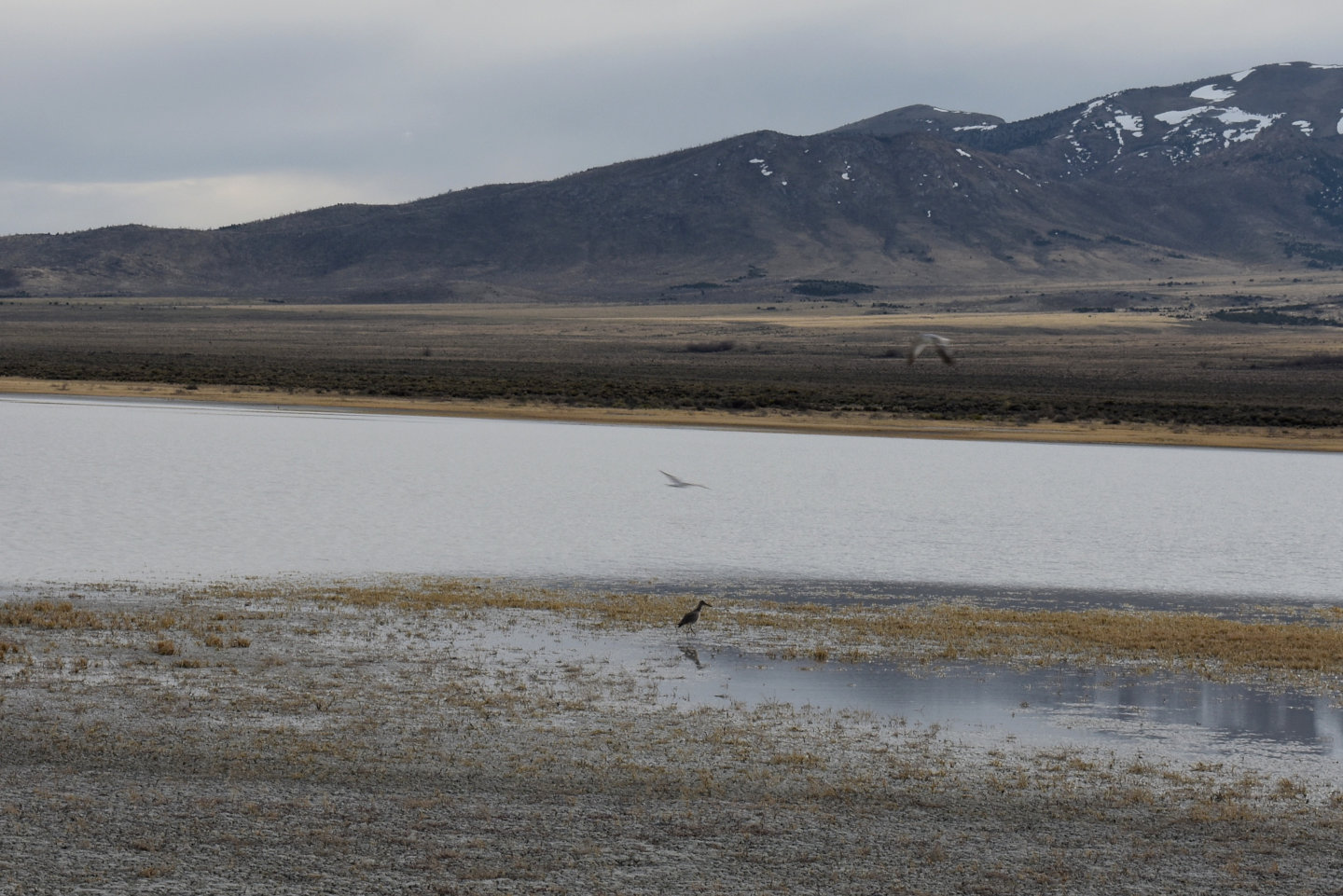
A large wading bird that may be a willet on the northern shore of “Snow Water Lake”. It is periodically pecking at the water as if feeding or trying to feed. I didn’t see any animals in the water so I don’t know what the gulls and willet(?) could be eating, if anything. There are also 2 blurred gulls flying in opposite directions above the willet. The area with dried yellow salt grass was dry before the wind blew water over it. Mud cracks have been submerged but are still visible through shallow water.
What Can We Learn from the Ponds in Clover Valley?
About the only potential fairy shrimp habitat in southern Clover Valley is “Snow Water Lake”. There may be small ponds scattered around on the surrounding clay flats like Luning Playa Narrow Pond in Soda Spring Valley but finding them would be quite a chore.
I didn’t find fairy shrimp on 1 visit to “Snow Water Lake” but the windy conditions may have been particularly unfavorable. If the fairy shrimp stayed in deeper water to avoid the wind-driven waves, I wouldn’t have seen them. Moreover, the lake is huge and I looked at only a small part of it.
The gulls and wading birds at “Snow Water Lake” suggest some edible animal lives in the water but I didn’t see what it was.