Beauty Peak East Pond
Beauty Peak West Pond
What Can We Learn from the Ponds in the Bodie Hills?
The Bodie Hills is a unique topographic feature. It is an upland terrain of rolling to locally steep hills between the high peaks of the Sierra Nevada to the west, the steep Wassuk Range to the east, the Mono Lake basin to the south, and the Sweetwater Mountains and Pine Grove Hills to the north. The Bodie Hills are about 30 km (19 miles) from Bridgeport eastward across the hills to Aurora and about 33 km (20 miles) from California 167 northward to the East Walker River canyon. Part of the reason for the atypical topography is the abundance of volcanic rocks younger than about 10 million years old. This has resulted in some volcanic land forms, such as cones and table lands. The elevation favors the accumulation of snow in the winter and spring but precipitation is limited by the rain shadow effect of the Sierra Nevada.
Elevations in the Bodie Hills range from lows of about 2,000 m (6,560′) at the north end and 2,200 m (7,220′) elsewhere to highs of 3,120 m (10,240′) on Potato Peak. There are several peaks higher than 2,700 m (8,860′) but most of the area seems to lie between 2,300 m (7,550′) and 2,600 m (8,530′).
The hills are covered by sagebrush with small groves of aspen in the wetter spots. Pinyon woodland is common on steeper slopes around the periphery of the Bodie Hills but generally not on the rolling uplands. This may be the result of extensive wood cutting and fires since the mines at Bodie were discovered over 100 years ago and unfavorable conditions for pinyon regeneration, as on Bald Mountain in the Pine Grove Hills to the north.
The Bodie Hills are mostly public lands managed by BLM but the northern part around Masonic Mountain and the eastern margin (within Nevada) are on the Bridgeport Ranger District of the Humboldt-Toiyabe National Forest. Bodie State Historic Park is in the middle of the Bodie Hills around the mining town of Bodie. There are extensive, widespread private lands. Most are along streams or near springs. Bridgeport, and consequently US 395 and California 182 are at the western edge of the Bodie Hills. Mono County 270 leads from US 395 to Bodie State Historic Park. California 167 passes just south of the hills. The Humboldt-Toiyabe National Forest’s recreation map of the Bridgeport Ranger District show 3 WSAs covering much of the central part of the Bodie Hills: Bodie Wilderness Study Area, Bodie Mountain Wilderness Study Area, and Mount Beideman Wilderness Study Area. There is also an Area of Critical Environmental Concern encircling Bodie State Historic Park.
Beauty Peak East Pond (Bishop BLM Office, Bodie Wilderness Study Area)
___This map is a screenshot of The National Map (Go to The National Map). The U.S. Geological Survey generally does not copyright or charge for its data or reports (unless printed). A pond location is indicated by an “X”, which corresponds to the coordinates given in the data spreadsheet. Labels in quotations are from 7.5-minute topographic quadrangles.
___Red lines are the U. S. National Grid with a spacing of 1,000 m and intersection labels consisting of the UTM zone (e.g., 11S, 12T), a 2-letter 100-km square designation (e.g., LC, XN), and a 4-digit number. The first 2 digits of the number represent the 1,000-meter Easting and the second 2 digits the 1,000-meter Northing, as seen in the example Easting and Northing. Unlike latitude and longitude, the National Grid is rectilinear on a flat map, the units of abscissa and ordinate have equal lengths, and the units (meters) are measurable on the ground with a tape or by pacing.
___Gray shading represents private land as traced from the PAD-US 2.0 – Federal Fee Managers layer of The National Map. Other lands are public.
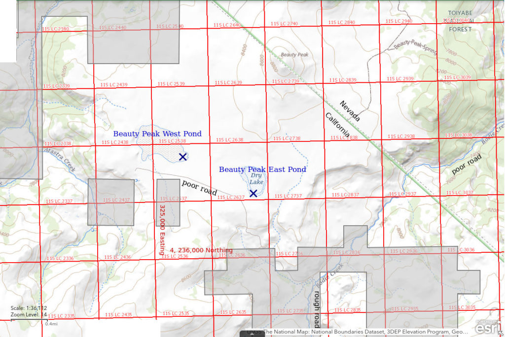
Beauty Peak East Pond is 21 km (13 miles) east of Bridgeport. The pond is shown with a stipple pattern on the 1:100,000-scale BLM map over an area of about 350 m by 600 m (1,150′ x 1,970′). It is 2 km (1.2 miles) south of Beauty Peak, which is on the California-Nevada border.
The location is most easily accessed from Bodie State Historic Park, which is only 4.5 km (2.8 miles) to the south. The park can be reached on the well-maintained Mono County 270 road which joins US 395 about 5 miles south of Bridgeport. A road from the park descends Bodie Creek and eventually Bodie Creek Canyon in Nevada. The road in Bodie Creek Canyon has generally been bad over the years impeding access from the east. It was mostly obliterated by the spring run-off of 2017. Mineral County restored the road, probably in fall 2019, making it passable once again to high-clearance 4-wheel-drive vehicles. A poor road leads about 2 km (1.2 miles) up the hill from the Bodie Creek road to the pond. The meadows along Bodie Creek in California are mostly private land but there is probably a public right-of-way.
Elevation: 2,523 m (8,280′)
May 15, 2019
I drove only about 2 miles past the cringe-worthy one-lane bridge at the mouth of Bodie Creek Canyon (the adjacent ford is no better) before parking. The road only gets worse from there and is impassable due to snow and mud. At the pond, there is one small snowbank shaded by the outcrop on the east side. The southwest shore of the pond is wet and boggy.
- 350 m x 600 m, based on the BLM map but could be larger today; depth not estimated.
- Water is opaque pale brown.
- Pale gray fairy shrimp 10-15 mm but the wind is so strong I can’t even photograph those in the net.
- No other animals noted.
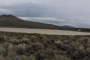
View northeast across Beauty Peak East Pond with Beauty Peak at left and Corey Peak in the Wassuk Range on the horizon at right.
June 12, 2019
Hiked in from the north rather than up the canyon this time with a stop on top of Beauty Peak for a great view. It still looks like all of the pond area is occupied by water. Numerous, small patches of snow persist in the Bodie Hills.
- 350 m x 600 m, based on the BLM map but could still be larger today; possibly up to 30 cm deep away from shore.
- Cloudy pale brown water.
- Large gray fairy shrimp about 25 mm long with very dark material the entire length of the intestine; females have 1-2 dozen eggs in ovisacs about 3/4 length of abdomen; can’t make out the antennae II of the males.
- Also netted 5 mm reddish-brown clam shrimp (Conchostraca) and a 25 mm long dytiscid larva (order Coleoptera, family Dytiscidae).
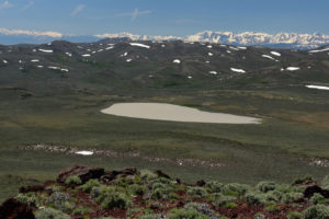
Beauty Peak East Pond from Beauty Peak, with the Sierra Nevada in the distance beyond the Bodie Hills.
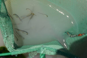
Big fairy shrimp in Beauty Peak East Pond caught in net. Some of the females have pale brown eggs.
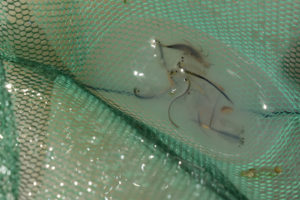
Net haul from Beauty Peak East Pond with small clam shrimp below and to right of center and big dytiscid larva above center. I dumped the net quickly so the dytiscid larva wouldn’t have a chance to start chewing on the fairy shrimp. There are both brown and pale yellow eggs.
April 2, 2021
Parked at the ford in the middle of Bodie Creek Canyon this time. That turned out to be a good call as the upper part of the road in California was very muddy and the road up to the pond had snowbanks as well as mud.
- Snow only.
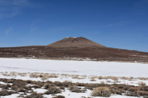
View north across Beauty Peak East Pond, with Beauty Peak in the background. Too early, obviously. There was little snow over the winter so I was afraid I would miss the hatch if I didn’t get here early. The big question: Will there be enough water when the snow melts?
April 30, 2021
The snow has melted. The pond has water but there isn’t much. Was it enough for the fairy shrimp to hatch?
- Water over about 200 m x 400 m; mostly less than 5 cm deep but maybe up to 10 cm somewhere.
- Opaque very pale brownish-gray water.
- Abundant pale gray and some darker fairy shrimp 10-15 mm long and maybe some less than 10 mm (they’re swimming too fast for good estimate).
- No other aquatic animals observed.
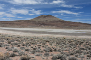
Beauty Peak East Pond and Beauty Peak. The water is very pale and surrounded by dark wet mud. Rocks out in the middle aren’t covered so the water is very shallow. The limited extent of the water suggests it may never have covered all of the pond area.
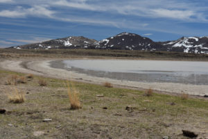
View east along the north shore of Beauty Peak East Pond, with Brawley Peaks in the distance. The water is encompassed by a band of mud where some fairy shrimp have been trapped in isolated puddles.
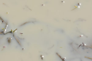
Fairy shrimp in Beauty Peak East Pond. Several fairy shrimp are swimming close enough to the water surface to be seen as ghostly shapes with dark tails, which are their abdomens.
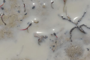
Fairy shrimp in the very shallow water of Beauty Peak East Pond. Above center is a fairy shrimp on its side due to water depth less than 1 cm and at upper right is one with its back breaching the water surface while a barely visible fairy shrimp (look for its 2 black eyes) is swimming normally below center.
This generation was born into a pond with not much water and will have short lives. Regardless, these are the only lives they know and I am lucky to have seen a part of their brief existence. This generation probably won’t have enough time to produce eggs but there will be future populations here nonetheless. The resting egg hedging strategy of fairy shrimp ensures that not all eggs hatch when a pond fills. Unhatched eggs remain in the pond’s egg bank and will be available for future pond fillings (see Resting Eggs of Fairy Shrimp and Their Hatching).
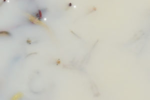
Well, hello! I’ve never seen this before (and only noticed it in the photograph). 3 fairy shrimp in Beauty Peak East Pond are looking up out of the water as if they are standing on their abdomens. Why would fairy shrimp look up out of the water? How do I even know if they are looking up out of the water? Compound eyes don’t have narrowly directed vision like the stereoscopic vision of owls and humans. Fairy shrimps’ third eye, the ocellus, can be seen as a black speck in the middle of the forehead of the fairy shrimp below center.
Beauty Peak East Pond Fairy Shrimp Video 2021-04-30a-r, Bodie Hills.
For a 3-minutes 12-seconds video of fairy shrimp in very shallow water of Beauty Peak East Pond, click on the video player above. There is no audio. The video opens with a view to the east across the pond. The water is too turbid to see fairy shrimp in most cases but it is so shallow on the mud flat where I am standing that I can get glimpses of them. The camera is finally close enough to the water for the fairy shrimp to be seen as dark, darting shapes just below the surface at 0:42. There are quite a lot of them. I zoom in at another location at 1:49. The water is alive with fairy shrimp. Their rapid swimming back and forth may be avoidance of other fairy shrimp. Alternatively, the jerking and rapid swimming could be a reaction to the shallow water and an attempt to find deeper water. At 2:35, some fairy shrimp can be seen moving their legs rapidly in place with no forward motion. This may be feeding in place and, of course, they are breathing as well.
Beauty Peak East Pond Fairy Shrimp Video 2021-04-30b-f, Bodie Hills.
For a 41-seconds video of fairy shrimp swimming in my net at Beauty Peak East Pond, click on the video player above. There is no audio. These fairy shrimp are also swimming very rapidly even though the water they came from is deeper.
Beauty Peak East Pond Fairy Shrimp Video 2021-04-30c-f, Bodie Hills.
For a 44-seconds video of a closer view of the fairy shrimp on the mud flat at Beauty Peak East Pond, click on the video player above. There is no audio. In this video, you can see how the fairy shrimp flex their bodies to jerk one way or the other. Some of them even look like they are hopping. Try slowing the video down for a better view.
Beauty Peak West Pond (Bishop BLM Office; Bodie Wilderness Study Area)
Beauty Peak West Pond is about 1 km (0.6 mile) west of Beauty Peak East Pond and is larger. The stipple pattern on the 1:100,000-scale BLM map is about 600 m x 800 m (1,970′ x 2,620′).
For access, see Beauty Peak East Pond. The primitive road that leads up to Beauty Peak East Pond from Bodie Creek continues as a 2-track to Beauty Peak West Pond. The road does speed up the hike through the sagebrush.
Elevation: 2,523 m (8,280′)
May 15, 2019
Saw a few antelope on the hike from Beauty Peak East Pond. There is a long snowbank against the outcrop southeast of the pond. The basin seems flatter than that of Beauty Peak East Pond so the depth could be less even though the pond is bigger.
- 600 m x 800 m, based on BLM map but could be larger today; depth uncertain.
- Opaque pale brown water.
- Pale gray fairy shrimp 10-15 mm long but waves impair the visibility.
- No other animals noted.
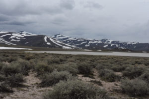
View southwest across Beauty Peak West Pond, with Bodie Hills in the distance.
June 12, 2019
Extensive areas of grass growing in the water, which helps water clarity.
- Pond is almost as big as before, probably 500 m x 700 m; possibly up to 30 cm deep near center.
- Murky pale brown with moderate visibility in shallower areas.
- Fairy shrimp 25 mm long, not as common as in Beauty Peak East Pond, at least near shore; rare fairy shrimp about 10 mm long suggest a second hatch; large females have eggs.
- Common tadpoles 15-20 mm long, dytiscid larvae (order Coleoptera, family Dytiscidae) about 20 mm long, beetles, 5 mm clam shrimp (Conchostraca), which sometimes grab vegetation as if feeding on it.
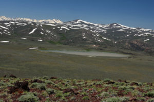
Beauty Peak West Pond from Beauty Peak, looking southwest. The Sierra Nevada are on the horizon at left.
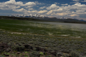
Looking northwest across Beauty Peak West Pond toward the Sweetwater Mountains. There’s lots of grass growing in the water on the southern shore.
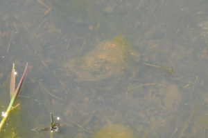
Several fairy shrimp in the murky water of Beauty Peak West Pond. Look for the pale colored food in their intestines and their pairs of black eyes.
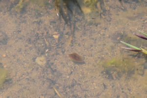
A brown clam shrimp in Beauty Peak West Pond swimming through the near-shore vegetation.
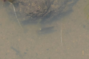
Beauty Peak West Pond with a swimming dytiscid larva below the rock at center. Its forked “tail” is at right.
April 2, 2021
There was nearly continuous crusty snow on the vehicle track and in the sagebrush on the hike over from Beauty Peak East Pond.
- Minor irregular patches of water less than 30 m across on the snow; depth less than 2 cm.
- Water is clear; extensive ice.
- No fairy shrimp.
- No other aquatic animals.
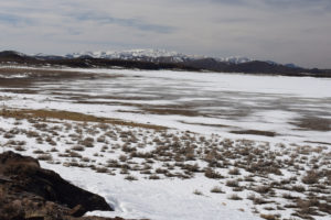
View west across Beauty Peak West Pond with Sweetwater Mountains in the distance. The gray areas have shallow water, sometimes on ice, sometimes on the ground. Too early here, too.
April 30, 2021
The season is still early – the willows and aspen along Bodie Creek don’t have leaves, the cushion phlox isn’t blooming yet, north-facing slopes and even the basalt outcrop by the pond still have snowbanks – but there is no water. From this, it appears that Beauty Peak East Pond has an advantage for filling with snowmelt.
- Dry.
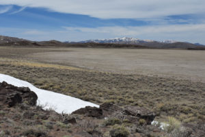
Beauty Peak West Pond, with the Sweetwater Mountains in the distance. There wasn’t even enough water to green up the pond bottom.
What Can We Learn from the Ponds in the Bodie Hills?
2 very large ephemeral ponds in the Bodie Hills have fairy shrimp. They form from snowmelt in the spring and are shallow with clay floors and opaque water. Bring your net!
These 2 ponds also have another branchiopod order, clam shrimp (Conchostraca, or the 2 orders Spinicaudata and Laevicaudata).
The Bodie Hills are downwind of “Mono Lake” and are likely covered with wind-blown resting eggs of the “Mono Lake” fairy shrimp, Artemia monica. However, the general lack of mineral efflorescence around the ponds suggests the TDS of the ponds in the Bodie Hills is unlikely to be high enough to support A. monica or other species of the genus Artemia.
Although I didn’t see any birds at the Bodie Hills ponds, “Mono Lake” attracts a lot of migratory water birds. It is likely that some proportion of the birds that visit “Mono Lake” also visit ponds in the Bodie Hills. These birds could disperse fairy shrimp eggs from or to the Bodie Hills ponds.
Ponds in the Bodie Hills are only about 29 km (18 miles) south of ponds in the Pine Grove Hills and at about the same elevation. Ponds in the Bodie Hills have opaque water while those in the Pine Grove Hills have murky to clear water. Are the fairy shrimp the same species?
Coda
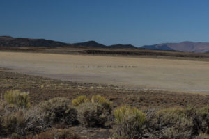
Pronghorns (antelope) sprinting across Beauty Peak West Pond.
After admiring the golden aspen in the Bodie Hills one fall, I hiked by Beauty Peak West Pond and came upon a herd of antelope (pronghorns) in the sagebrush south of the pond. There was no cover so they saw me from a long way off, maybe more than 300 m (980′) away. They didn’t show much concern but circled up and began trotting through the sagebrush toward the dry pond, with an occasional glance back at me. When they got to the pond, it was like they flipped a switch. The whole herd began sprinting across the pond bed. The faster the ones in front ran, the faster the ones behind tried to catch up, and the faster the ones in front ran. They were not running away from me; they were running across my field of vision. They strung out into a line and hit their peak speed at about the middle of the pond bed. If this was their response to a threat from me, it was way overdone. I was standing still and gawking. They had already seen my slow, stumbling gait through the sagebrush anyway. Then they hit the far side of the pond and the switch flipped off. They slowed to a walk. As the herd wheeled to the right, many looked my way. “What do you think of that, you clumsy 2-legged sloth?”, I imagined they might have thought.
The speeding antelopes’ hooves may have damaged a few fairy shrimp eggs but that’s okay. It’s not all about fairy shrimp, of course.
This part of California does not have a pronghorn hunting season but the any-weapon season in the adjacent part of Nevada was open.