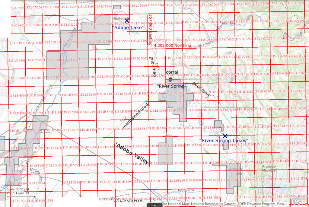
“Adobe Lake”
“River Spring Lakes”
What Can We Learn from the Ponds in Adobe Valley?
Adobe Valley is a very nearly closed basin southeast of Mono Lake near the Nevada border. The outlet of Black Lake sneaks out through the granite ridge to the southeast and into Benton Valley. The main part of the valley is about 15 km (9 miles) long from northwest to southeast and about 10 km (6 miles) wide. The 1:100,000-scale BLM map shows intermittent water bodies for “Adobe Lake”, a multitude of the “River Spring Lakes”, “Antelope Lake”, and a permanent water body for “Black Lake”.
The floor of Adobe valley is at an elevation of 1,950-2,000 m (6,400-6,560′). Glass Mountain, named for the abundant obsidian, is to the south and rises to 3,390 m (11,120′). Granite Mountain is to the west and reaches 2,719 m (8,920′). Maximum elevations on Antelope Mountain to the east, in the Adobe Hills to the north, and in nameless hills to the northwest are below 2,400 m (7,870′).
Much of the central part of Adobe Valley is grassland. Sagebrush predominates around the margins and on the flats in places. Desert scrub occurs around “Adobe Lake”.
There are large blocks of private land around Black Lake, Antelope Lake, River Spring, to the southwest of “Adobe Lake”, and in the western part of the valley.
The PAD-US 2.0 – Federal Fee Managers layer of The National Map indicates that some of the lands shown as private on the 1988 1:100,000-scale BLM map are now owned by California. The large block south of River Spring is now the “River Spring Lakes Ecological Reserve” (California Department of Fish and Wildlife, 2016, “River Spring Lake” Ecological Reserve Final Land Management Plan, 125 pages in pdf file). The purpose of the reserve is to protect the Owen pupfish, which has not been identified there, and to maintain habitat for “waterfowl and shorebirds”. Introduced Amargossa pupfish are the only fish currently known in the reserve. They would probably eliminate fairy shrimp from any perennial water bodies. The only invertebrate mentioned in the management plan is a springsnail. According to the management plan, hiking and hunting are allowed but camping is prohibited.
“Adobe Lake” (Bishop BLM Office)
___This map is a screenshot of The National Map (Go to The National Map). The U.S. Geological Survey generally does not copyright or charge for its data or reports (unless printed). A pond location is indicated by an “X”, which corresponds to the coordinates given in the data spreadsheet. Labels in quotations are from 7.5-minute topographic quadrangles.
___Red lines are the U. S. National Grid with a spacing of 1,000 m and intersection labels consisting of the UTM zone (e.g., 11S, 12T), a 2-letter 100-km square designation (e.g., LC, XN), and a 4-digit number. The first 2 digits of the number represent the 1,000-meter Easting and the second 2 digits the 1,000-meter Northing, as seen in the example Easting and Northing. Unlike latitude and longitude, the National Grid is rectilinear on a flat map, the units of abscissa and ordinate have equal lengths, and the units (meters) are measurable on the ground with a tape or by pacing.
___Gray shading represents private land as traced from the PAD-US 2.0 – Federal Fee Managers layer of The National Map. Other lands are public.
___Some areas shown as private land are now state lands, such as the “River Spring Lake” Ecological Reserve adjacent to River Spring.

“Adobe Lake” is 22 km (14 miles) northwest of Benton at the northern end of Adobe Valley. On the 1:100,000-scale BLM map, the intermittent lake pattern is about 1,200 m (3,940′) long and up to 600 m (1,970′) wide. The lake is on public land but there is a small block (about 20 acres) of private land north of the northwest end of the lake and approximately 3 sections (about 1,920 acres, 780 hectares) of private land starting about 300 m (980′) southwest of the northwest end of the lake.
“Adobe Lake” is accessible from California 120 east of Mono Lake and northwest of Benton Hot Spring. There is a well-maintained county road from California 120 to River Spring. A non-maintained road going north from River Spring intersects a power line and its access road about 2,000 m (6,560′) southeast of “Adobe Lake”. The road along the power line does not look good but passes within 1,000 m (3,280′) of “Adobe Lake”. The 1:100,000-scale BLM map shows a road to a windmill about 700 m (2,300′) west of “Adobe Lake” and north of the private land. To reach it, you would turn north off California 120 just east of its sharp bend and drive through about 1 mile of private land if public access is allowed.
Elevation: 1,976 m (6,485′)
May 30, 2018
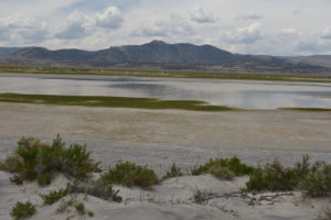
There is a patch of water at the north end of the mostly dry lake and the sandy soil allows easy access to the water’s edge. The lake is ringed by sand dunes partially vegetated with greasewood. A couple of horses graze on the far side of the water.
- 150 m x 300 m; depth not estimated but almost certainly greater than 10 cm deep.
- Cloudy pale gray to brown with patches of floating green algae.
- No fairy shrimp.
- Nothing seen swimming in the water where not obscured by surface scum.

Pond in “Adobe Lake” with Granite Mountain in distance to west. The greasewood on the sand dune in the foreground has new leaves.
“River Spring Lakes” (Bishop BLM Office)
“River Spring Lakes” are small to large seasonal ponds (as indicated by the intermittent lake pattern on the 1:100,000-scale BLM map) strung out for about 6 km (3.6 miles) from River Spring to the north end of “Antelope Lake” in eastern Adobe Valley. They are generally 12-17 km (7.5-10.5 miles) northwest of Benton. Some of the ponds are on private land and some are on public land.
To reach “River Spring Lakes”, turn off California 120 and follow the well-maintained road to River Spring. There is a corral at River Spring. A non-maintained road passes the corral and swings to the southeast and out to the east of the ecological reserve. The lack of “No Trespassing” signs suggests that there is a public right-of-way. The road quickly degrades to a 2-track and is difficult to follow more than a mile from River Spring.
Elevation: 1,975 m (6,480′)
May 23, 2018
Some of the ponds are dry, some have damp mud, and one of the larger ponds near “Antelope Lake” has some water. I couldn’t get close enough to see anything in the water because of the soft mud. Herds of horses and antelope graze in the distance.
- Less than 20 m wide and less than 50 m long; probably less than 3 cm deep.
- Water clear to murky.
What Can We Learn from the Ponds in Adobe Valley?
The ponds look like potential fairy shrimp habitat but one visit has not determined whether any are present.